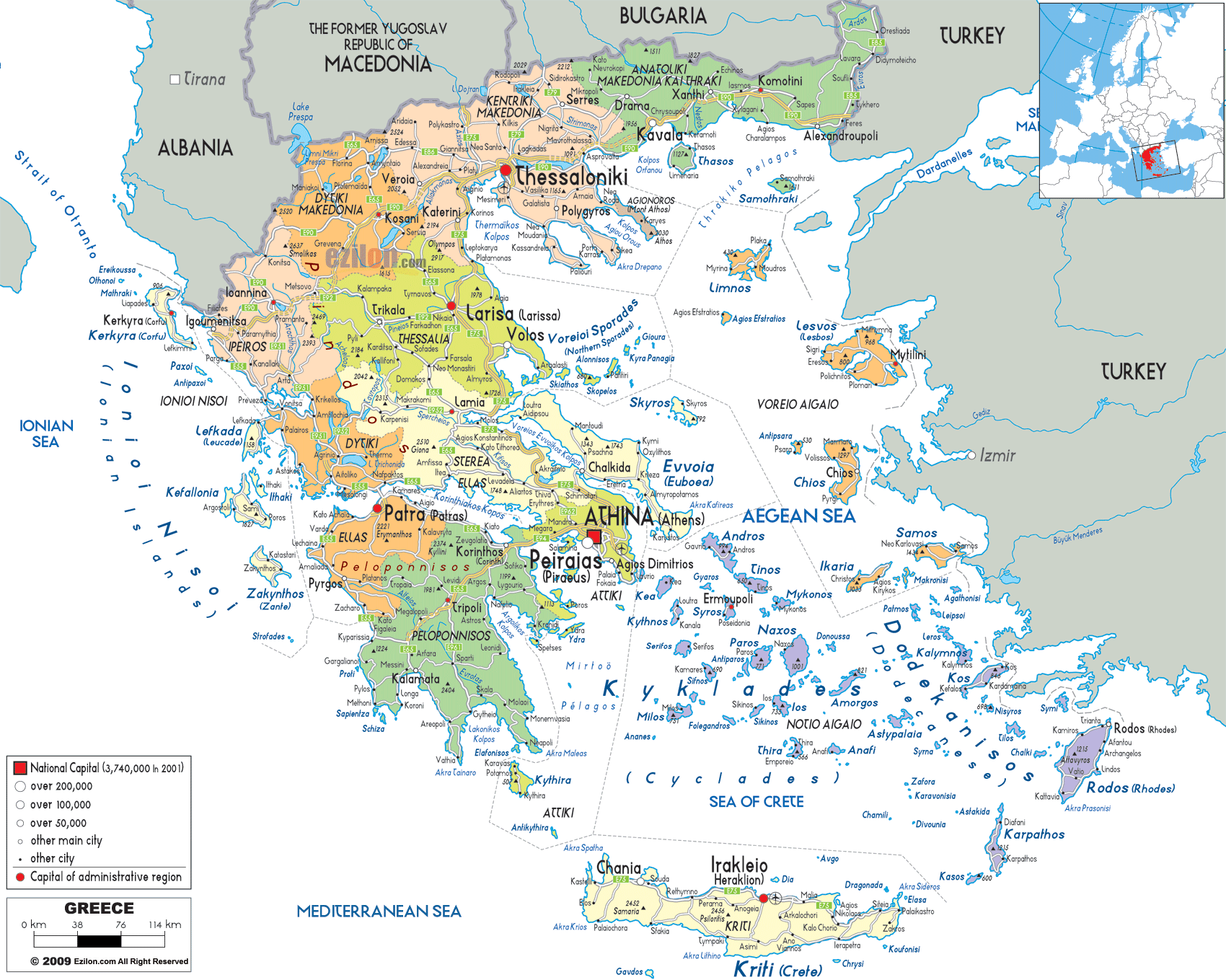
Description: Detailed large political map of Greece showing names of capital cities, towns, states, provinces and boundaries with neighbouring countries.
 Map of Greece, with cities, counties, prefectures and roads network. As you examine this detailed map of Greece, you're witnessing far more than prefectures administrative boundaries and city names - you're looking at the organizational framework of a civilization that has shaped Western democracy for over two millennia. Greece is a country where the ancient world mixes with the problems found in modern governance. The hard coastline that the country sports gives way to mountains, and regions with varying political stories and cultural identities.
Greece is both complex and sophisticated, as revealed by the map's colouration and symbolism. Notice immediately how Athens (Athina) is marked with a distinctive red square in the center-south of the mainland, this isn't just a cartographic convention, but a reflection of the centralized nature of Greek governance that has persisted since ancient times. The various sized circles representing cities of different population categories tell the story of the urban hierarchy that has evolved over centuries of political and economic development.
This political map is interesting because it shows how Greece has to govern a country characterized by a mountainous mainland peninsula and scattered across the three seas (Aegean, Ionian, and Mediterranean) with 6000 islands and islets. With 13 administrative regions, 74 regional units, and only 227 inhabited islands out of thousands, Greece presents one of Europe's most complex cases of territorial administration.
As you move towards the map's extreme north, the large area of Macedonia, split into three administrative units, catches the eye. This is Greece's largest area and it is also its most geopolitically sensitive border.
Western Macedonia appears orange on the map because it is mountainous. Kozani, Grevena, Kastoria and Florina are cities in Greece that display a settlement pattern highlighting the vital role of rivers and valleys. Kozani, serving as the regional capital, sits strategically in what the map shows as a valley system. Though not visible on this political representation, this area encompasses some of Greece's most important energy-producing regions.
Notice how the international borders with Albania and North Macedonia (labeled as "The Former Yugoslav Republic of Macedonia" on this map) create irregular lines across the northern edge. These boundaries follow mountain ridges and river valleys that have been contested and negotiated for over a century. The Prespa Lakes area, visible near the tri-border region, represents one of Europe's most complex international zones where three nations meet.
Central Macedonia (Kentriki Makedonia) dominates the north-central area, and immediately Thessaloniki draws your attention—marked with a prominent red dot indicating its status as Greece's second-largest city and a regional capital. The map shows Thessaloniki's strategic position at the head of the Thermaic Gulf, with the Chalkidiki Peninsula extending southeastward like three fingers into the Aegean Sea.
Surrounding Thessaloniki, you can see Katerini to the south, Serres to the east, and Veroia to the west, forming a network of secondary administrative centers. The map reveals how these cities are positioned to take advantage of the fertile plains while maintaining access to mountain passes that have served as trade routes for millennia.
The Chalkidiki Peninsula deserves special attention on the map. While shown as part of Central Macedonia's administrative territory, the three peninsulas (Kassandra, Sithonia, and Athos) each have distinct political characteristics. Mount Athos, the easternmost peninsula, operates under unique autonomous status within the Greek state - a thousand-year-old monastic republic that maintains its own governance structure.
Eastern Macedonia and Thrace (Anatoliki Makedonia kai Thraki), on the map's far northeast, has political importance beyond what we would expect from this small, remotely located area. That Drama, Kavala, Xanthi, Komotini, and Alexandroupoli is clearly marked, reveals the identity politics of the region.
Kavala is an important port city and economic center on the Aegean coast. The location of one of the main Greek ports is closest to the Bulgarian border which links trading in Balkans. Alexandroupoli, located on the Turkish border, is the easternmost city in Greece and an administrative centre in the Evros River valley which forms the border with Turkey.
Thrace quite literally represents the easternmost extension of Greek territory, and the position of Thrace presents distinctive political complications. The Evros River clears visible to the east clearly states regional border but also international border with Turkey which has important ramifications for Greek internal and external policy.
The two major administrative towns are Komotini and Alexandroupoli, but they have political importance that is not proportionate to their size. From Turkey, the region's largest Muslim minority population. This Greek minority’s political rights and cultural preservation are guaranteed under international treaties. The administrative boundaries encompass a complex web of minority rights, religious freedoms, and cultural autonomy that makes Thrace unique within the Greek political system.
Moving southward on the map, Thessaly (Thessalia) unfolds as one of Greece's most important agricultural and administrative regions. Larisa, prominently marked as the regional capital, sits in the center of what the map shows as the Thessalian Plain - one of Greece's most fertile agricultural areas, though the political map doesn't show topographical details, the city's central position indicates its role as the administrative hub for this crucial region.
Volos, fronting the Pagasetic Gulf, is the principal port and industrial town of the area. It has a strategic position between central Greece and the north as shown in the map. Ferries to the Sporades Islands depart from Volos Cargo, whose main port serves as a very important link in the island administration of Greece.
The town of Trikala is located in The western part of Thessaly, and Karditsa in the central plain make up the administrative needs of the region. Playing host to some of Greece’s most inaccessible mountain communities, Trikala is the regional capital of the mountainous Thessalian terrain; while the regional town of Karditsa provides services to Greece’s agricultural heart.
The political map above does not name Meteora, but this famous area is within Thessaly, close to Kalambaka. This region poses unique governance challenges of balancing the need for the monastery which is a UNESCO World Heritage Site with the contemporary administrative needs.
Epirus (Ipiros) occupies the map's northwestern part, the political character of which hints at its geography. This area has been one of the more remote and politically different places in Greece bordered by Albania to the north and by the Ionian Sea and Albania to the west.
Ioannina is the city of Epirus that is the regional capital. The city position shows that it was the administrative town of the mountainous northwest of Greece. The politics of Ioannina go beyond just the headquarters of the current administration, as it was the capital of a semi-autonomous zone under Ottoman rule and through various political changes the continued political and cultural capital of Eprius.
The map shows Epirus's challenging topography through its borders and city locations, including some of Greece's most remote mountain communities where traditional forms of local governance persist alongside modern administrative structures. The Albanian border running along Epirus's northern edge represents one of Greece's most complex international frontiers, encompassing areas with significant Greek minority populations in Albania and Albanian minority populations in Greece.
Central Greece (Sterea Ellas) occupies a crucial position on the map, serving as the bridge between northern and southern Greece. Lamia, the regional capital, sits strategically at what the map shows as the southern approach to the Thessalian Plain, controlling the narrow passage that has been militarily and politically significant since ancient times—the famous Thermopylae battlefield lies within this region's current administrative boundaries.
Chalkida, located on the island of Euboea (Evia), represents one of the most interesting aspects of Greek political geography. Despite being on an island, Chalkida and all of Euboea are administered as part of Central Greece rather than as a separate island region. This administrative arrangement reflects historical patterns of governance and economic integration dating back centuries.
Agrinio, located in the western part of the area, acts as the second administrative centre while other smaller towns make up the local government centre network. In Greece, regional governments collaborate with municipalities in different geographical areas. Each serves as a useful layer in the country’s system of local government.
Attica (Attiki) may appear relatively small on the map, but its political significance is immediately apparent from the red square marking Athens (Athina) as the national capital. This region represents the political, economic, and administrative heart of modern Greece.
Athens dominates Attica, but the region includes numerous other significant cities and municipalities. Piraeus, Greece's largest port, sits just southwest of Athens and serves as the country's primary maritime gateway. The administrative relationship between Athens and Piraeus reflects complex urban governance challenges—coordinating policy across a metropolitan area that includes dozens of separate municipalities.
The map reveals the extensive sprawl of Athens, with areas such as Agios Dimitrios, Peristeri and Kifisia identified. Each is a separate municipality with its own local government, which creates a complex set of relations, coordinated at the regional level.
Attica's boundaries extend eastward to include Marathon and other historically significant areas, while its southern boundary encompasses Saronic Gulf islands administered as part of the Athens region rather than as separate island territories.
The Peloponnese (Peloponnesos) is a major peninsula joined to the rest of the country by the Isthmus of Corinth. This Region’s Political Geography Shows Its Serious Importance and Problems in Today’s Administration
Patras (Patra), the largest city in the Peloponnese area of Greece and a clear capital of the place. The city's strategic position at the entrance to the Gulf of Corinth reveals its importance - controlling maritime access to central Greece while serving as the primary port for western Peloponnese and maintaining ferry connections to Italy.
The map shows the Peloponnese's diverse urban centers: Kalamata in the south, serving as the region's agricultural center and secondary port; Tripoli in the mountainous interior, representing the administrative challenges of governing Greece's rural areas; and Corinth near the isthmus, controlling the land bridge between the Peloponnese and mainland.
The town of Sparta (Sparti), which is located in the southeast of the peninsula, is of great historical importance. The survival of the city and administrative status is an example of the continuation of ancient settlement patterns in contemporary Greek administration, as it serves as the administrative centre of Laconia.
The Ionian Islands are also known as Ionioi Nisoi and are located on Greece's western shore. The map reveals their political character at once. These islands have been more linked with western Europe than with Greece, and their political culture still reflects this.
This was always the most important and biggest one and is the regional capital of the area – Corfu (Kerkyra). Corfu Town has strong signage that symbolizes the complex governance issues of the Greek islands. The island is close to Albania, which brings additional political and economic relations that must be managed carefully.
Kefalonia, with its capital at Argostoli, represents the largest of the southern Ionian Islands. Zakynthos, Lefkada, and smaller islands each present their own governance challenges. Due to Lefkada's connection to the mainland via a causeway, Lefkada exhibits unique administrative arrangements. Zakynthos is a large tourist destination, therefore the coordination effort of tourism development and environmental protection is high.
The North Aegean Islands (Voreio Aigaio) occupy a strategically sensitive position close to Turkey's coast, serving as Greece's eastern maritime frontier. Lesvos (Mitilini), the largest island in the area, world news has made it the landing spot for ships of refugees and migrants arriving from Turkey.
Chios, near the Turkish coast, has a complicated relationship with Greece and Turkey. Samos, Ikaria, Limnos each have their own governance issues Samos's proximity to Turkey makes it important in Greece's immigration and border control policies, while Ikaria's remote location creates different administrative needs.
The South Aegean Islands (Notio Aigaio) represent one of Greece's most economically important regions, encompassing both the famous Cyclades and Dodecanese island groups.
The Cyclades, including Mykonos, Santorini (Thira), Naxos, Paros, Andros, and Amorgos, have become synonymous with Greek tourism. Syros, with its capital at Ermoupoli, serves as the administrative center for the Cyclades. Ermoupoli was designed in the 19th century as a model neoclassical city and continues to serve as the political hub for the entire Cycladic archipelago.
The Dodecanese islands, including Rhodes (Rodos), Kos, Karpathos, and numerous smaller islands, present different governance challenges due to their position near Turkey. Rhodes, as the largest city and regional center, coordinates policies across an island group stretching over hundreds of kilometers of sea.
Rhodes city serves not only as a municipal center but as the administrative hub for the entire Dodecanese region. The smaller Dodecanese islands—Patmos, Leros, Kalymnos, Symi, and others—each maintain local governments while participating in regional coordination.
Crete (Kriti) stands apart as Greece's largest island and fifth-largest in the Mediterranean. Its division into four regional units—Chania, Rethymno, Heraklion (Irakleio), and Lasithi - reflects both geographic realities and administrative necessities.
Heraklion, marked as the island's largest city, serves as both regional capital and primary economic center. Chania in western Crete represents the island's second major administrative center. Agios Nikolaos and other small towns each have their local governance systems which make coordination so difficult across the large and diverse island.
Greece's land borders, clearly marked on the political map, represent some of Europe's most complex and politically sensitive frontiers. The areas on both sides of the Albanian border have significant minority populations. The border with North Macedonia raises questions of national identity and interpretive history. That is the border between the EU and a non-EU state and vice versa. Over time, the border has been made stronger and the river has been controlled.
The long and diverse coastlines and the numerous islands of Greece create complex maritime zones which need to be coordinated. The Greek islands in the Aegean Sea create special difficulties for maritime governance. Coordination with Italy is necessary for the Ionian Sea, while the Mediterranean Sea around Crete produces tourism, shipping, and immigration challenges.
The map clearly shows Greece's 13 administrative regions:
Attiki - The capital region centered on Athens
Central Macedonia - Northern Greece's economic powerhouse
Western Macedonia - Mountainous border region
Eastern Macedonia and Thrace - The eastern frontier
Thessaly - The agricultural heartland
Epirus - The western mountains
Central Greece - The continental bridge
Western Greece - Including parts of the Peloponnese
Peloponnese - The southern peninsula
North Aegean - Eastern island frontier
South Aegean - Tourism and traditional culture
Ionian Islands - Western maritime heritage
Crete - The great southern island
Certain challenges are more relevant than others in the various regions. The geography, economy and demography of a region influence its growth and development. However, all the regions must coordinate with both the local municipal bodies and the national authorities to implement the policy and deliver the services.
The map's legend reveals Greece's urban hierarchy through different sized symbols:
Red square: National Capital (Athens)
Red dots: Regional capitals
Large circles: Cities over 200,000 population
Medium circles: Cities over 100,000 population
Small circles: Cities over 50,000 population
Smallest circles: Other main cities
The hierarchy shows the political, economic and administrative developments spread over a long time. Most of the key functions are concentrated in some cities. Smaller cities, on the other hand, cover the governance requirements of local areas.
Looking at this political map, one can easily notice the economic activity in Athens and Thessaloniki makes political pressures between developed and underdeveloped areas. Governance challenges related to seasonal jobs and environmental protection confront island economies dependent on tourism. Difficulty related to poverty and depopulation of rural areas, especially hilly areas, are a concern.
Greece's position as a European Union frontier state creates unique governance challenges reflected in the political geography. Border regions and islands that serve as gateways have to have special administrative arrangements where local, national and international authorities must coordinate.
The political map represents the administrative framework for addressing environmental challenges and climate change impacts. Coastal Areas and islands are facing problems of rise in sea level and pollution in the ocean. On the contrary, mountain areas have environmental issues because of forest and water resource management.
This Greece political map shows that the country is complex. Greece is scattered across the Aegean and Ionian Seas and will require innovative governance. Greece’s international borders mostly reflect the legacy of the Balkan Wars та 1919-1945.
Each region, island, and city marked on this map represents not just an administrative unit but a community with its own identity, needs, and political culture. Greek political geography involves the study of how these varied communities are knitted together to form a working democratic state through a balance of local autonomy and national coordination, traditional culture and modern development, as well as domestic priorities and international obligations.
For geography students this map lays the foundation of understanding how physical geography influences political formations. Travelers get an insight into the political architecture of places they go to. For anyone interested in democracy and governance, Greece's political map provides a fascinating case study in how modern states adapt ancient democratic traditions to contemporary challenges.
The political map of Greece ultimately represents democracy in action—showing how millions of citizens across hundreds of communities, dozens of islands, and multiple regions work together to govern themselves while preserving their distinct identities and addressing shared challenges. It's a testament to the enduring power of democratic ideals that Greece gave to the world, adapted and evolved to meet the needs of a modern European nation in an interconnected global community.

Physical Map of Greece
Physical map and map image of Greece.

Road Map of Greece
Road map and map image of Greece.

Regional Directory of United States of America
Information and guide about United States of America and websites with American topics.

Regional Directory of Europe
Information and guide about Europe and websites with European topics.

Regional Directory of Australia
Information and guide about Australia and websites with Australian topics.