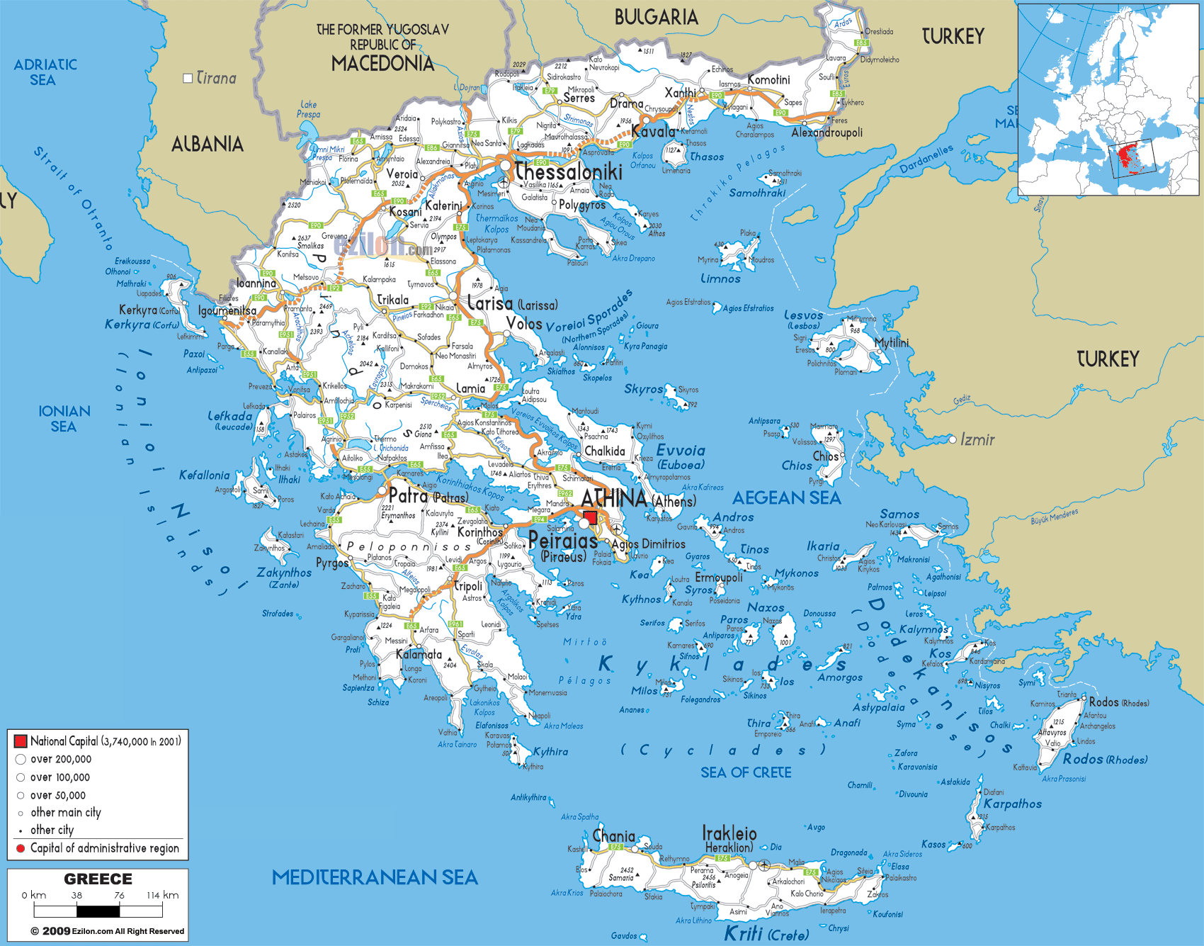
Description: Detailed clear large road map of Greece with road routes from cities to towns, road intersections to provinces and perfectures.
 Detailed map of Greece with Road Map of Greece with Highways and Expressways linking its cities and regions with neighbouring Albania, North Macedonia, Bulgaria and Turkey. Picture yourself planning the perfect Greek adventure, whether you're a local resident commuting between cities or a traveler dreaming of island-hopping and mountain exploration. This comprehensive road map of Greece reveals a sophisticated network of highways, coastal routes, mountain passes, and island connections that have been carefully developed to connect every corner of this geographically diverse nation.
Greece's road system tells a fascinating story of engineering triumph over challenging terrain. From the major highways that slice through mountain ranges to the winding coastal roads that hug dramatic clifftops, every route has been designed to showcase the country's natural beauty while providing practical connections between communities. The orange and red lines you see crisscrossing the map represent more than just asphalt and concrete - they're lifelines that connect ancient cities, modern ports, mountain villages, and island paradises.
What makes Greek roads particularly special is how they adapt to the landscape rather than dominate it. You'll notice how the major highways follow natural corridors - river valleys, coastal plains, and mountain passes—while secondary roads wind through terrain that would challenge even the most skilled engineers. This isn't just a transportation network; it's a carefully crafted system that allows you to experience Greece's incredible diversity while getting from point A to point B.
Thessaloniki serves as northern Greece's undisputed transportation capital, and looking at the road map, you can immediately see why. The city sits at the center of a web of major highways that radiate outward like spokes on a wheel, connecting Greece to the Balkans, Turkey, and the rest of Europe.
The A1 Highway (marked in red on the map) approaches Thessaloniki from the south, creating the primary north-south corridor that connects the city to Athens. This is Greece's most important highway - a modern, multi-lane expressway that cuts through some of the country's most challenging terrain. As you trace this route on the map, you'll notice how it follows the natural corridor between the Pindus Mountains and the coastal ranges, a path that travelers have used for over 2,000 years.
From Thessaloniki, the A2 Highway (Egnatia Odos) extends westward toward Ioannina and the Albanian border, while another major route heads eastward toward Kavala and the Turkish frontier. This east-west highway represents one of modern Greece's greatest engineering achievements, tunneling through mountains and bridging valleys to create a continuous connection across northern Greece.
Within Thessaloniki itself, you can see the ring road system that helps manage traffic flow around the metropolitan area. The city's position at the head of the Thermaic Gulf means that all north-south traffic must funnel through this area, making the local road network crucial for both regional and international transportation.
Kozani sits at a crucial junction where roads from Thessaloniki meet routes heading toward Ioannina and the Albanian border. The orange highway lines on the map show how the road system navigates the challenging Pindus Mountain terrain, following river valleys and utilizing mountain passes that have been strategic corridors for millennia.
The route from Kozani to Kastoria represents one of Greece's most scenic mountain highways. As you follow this orange line on the map, you're tracing a road that winds through the Aliakmon River valley before climbing into the highlands around Lake Orestiada. This isn't just a transportation route - it's a journey through some of Greece's most pristine mountain landscapes.
Florina, positioned near the North Macedonian border, serves as a crucial border crossing point. The road network here connects Greece to the broader Balkan highway system, with routes extending north toward Skopje and Belgrade. The strategic importance of this location is evident in how multiple road corridors converge on this relatively small city.
The coastal highway running from Thessaloniki to Kavala and Alexandroupoli represents one of Greece's most important transportation arteries. This route, marked in orange on the map, hugs the Aegean coastline while providing access to the region's major ports and cities.
Kavala serves as a regional transportation hub where the coastal highway meets routes heading inland toward Drama and the Rhodopi Mountains. The city's position on a natural harbor makes it a crucial link between the road network and maritime transportation to the islands.
Drama sits at the intersection of several important routes, including the road that heads north toward the Bulgarian border and the highway that connects to Serres and the central Macedonian road network. The city's position in a fertile valley between the Rhodopi Mountains and the coastal plain makes it a natural convergence point for regional traffic.
The Evros River crossing near Alexandroupoli represents Greece's primary land connection to Turkey. The bridge infrastructure here handles significant international traffic, making this one of the most strategically important road connections in southeastern Europe.
Larisa occupies one of the most strategically important positions in Greece's road network. Sitting in the center of the vast Thessalian Plain, the city serves as a hub where north-south traffic on the A1 Highway meets east-west routes connecting the Pindus Mountains to the Aegean Sea.
The A1 Highway passes directly through Larisa, making it a natural stopping point for travelers between Athens and Thessaloniki. But what makes Larisa particularly important is how it connects to the regional road network. Orange highway lines radiate outward toward Volos on the coast, Trikala in the west, and Karditsa in the southwest, creating a transportation web that serves the entire Thessalian region.
The route from Larisa to Volos is particularly significant because it connects the inland agricultural regions to one of Greece's most important ports. This highway follows the natural corridor created by the Pineios River as it flows toward the Pagasetic Gulf, providing a relatively easy route through terrain that could otherwise be challenging.
Volos represents a crucial intersection between the mainland road network and maritime connections to the Sporades Islands. The city's position at the head of the Pagasetic Gulf makes it a natural port, while its road connections to Larisa and the A1 Highway ensure easy access to the rest of Greece.
The road network around Volos includes the scenic route that circles the Pelion Peninsula. While not marked as a major highway on this map, this coastal and mountain road system provides access to some of Greece's most beautiful villages and beaches. The peninsula's road network is particularly important for tourism, connecting traditional mountain villages with seaside resorts.
Trikala serves as the primary hub for western Thessaly, where roads from Larisa meet routes heading toward the Pindus Mountains and Ioannina. The city's position in the Pineios River valley makes it a natural convergence point for regional traffic.
The route from Trikala to Kalambaka provides access to the famous Meteora monasteries. While this appears as a relatively short connection on the map, it's one of Greece's most important tourist routes, handling significant visitor traffic to one of the country's most spectacular attractions.
Karditsa, positioned south of Trikala, serves as another regional center where local roads converge. The city's road connections provide access to the southern Thessalian Plain and routes toward central Greece.
Lamia occupies one of the most strategically important positions in Greece's road network, sitting where the A1 Highway navigates between the Pindus Mountains and the coastal ranges. This is where north-south traffic must funnel through the narrow corridor that has been crucial to Greek transportation for over two millennia.
The A1 Highway approaches Lamia from the north after winding through the challenging terrain of southern Thessaly. South of the city, the highway continues toward Athens, but not before navigating some of the most dramatic mountain scenery in central Greece. The route passes near the famous Thermopylae pass, where the road follows the same corridor that has been used by armies and travelers since ancient times.
From Lamia, secondary roads branch westward toward the Pindus Mountains and eastward toward the coast. The western route provides access to mountain communities and eventually connects to the road network around Karpenisi, while the eastern route leads to coastal towns along the Maliakos Gulf.
As you trace the A1 Highway south from Lamia toward Athens, you're following one of Greece's most engineered road sections. The highway must navigate through the mountains of central Greece, utilizing tunnels, bridges, and carefully graded sections to maintain highway speeds through challenging terrain.
The route passes near Delphi, though the ancient site is accessed via a separate mountain road that branches westward from the main highway. This connection to Delphi represents one of Greece's most important cultural tourism routes, providing access to one of the ancient world's most sacred sites.
Chalkida represents one of Greece's most interesting transportation situations—an island city that's connected to the mainland by bridge. The Euripus Bridge creates a direct road connection between Euboea and the mainland road network, making the island accessible without ferry transportation.
The road network on Euboea follows the island's mountainous spine, with the main highway running north-south along the western coast. This route connects Chalkida to communities throughout the island, including the northern resort areas and the southern agricultural regions.
Secondary roads branch eastward from the main highway, providing access to the island's eastern coast and mountain communities. The island's road system demonstrates how Greek highway engineering adapts to challenging island topography while maintaining connections to isolated communities.
Ioannina serves as the capital of Epirus and the primary hub for northwestern Greece's road network. The city's position beside Lake Pamvotis in a mountain basin makes it a natural convergence point for routes crossing the Pindus Mountains.
The A2 Highway (Egnatia Odos) connects Ioannina to Thessaloniki in the east, representing one of Greece's most challenging highway engineering projects. This route tunnels through mountains, bridges deep valleys, and navigates terrain that would have been impossible for highway construction just a few decades ago.
From Ioannina, the A5 Highway heads south toward Arta and eventually Patras, creating the primary north-south corridor for western Greece. This route follows river valleys and mountain passes, providing a relatively direct connection through terrain that's naturally challenging for transportation.
The road to Metsovo and the Pindus crossing represents one of Greece's most scenic mountain routes. While not marked as a major highway on this map, this route provides crucial access to mountain communities and serves as an alternative crossing of the Pindus range.
Preveza, positioned on the Ionian coast, serves as a crucial link between the mountain road network and coastal transportation. The city's position near the mouth of the Ambracian Gulf makes it a natural port, while its road connections provide access to the broader Epirus region.
The Aktio-Preveza Bridge creates a direct connection across the gulf mouth, eliminating the need for ferry transportation and creating a continuous coastal route. This bridge represents a significant improvement in regional connectivity, particularly for tourism and commercial transportation.
Agrinio sits in the Acheloos River valley and serves as a regional transportation hub where routes from the Pindus Mountains meet roads heading toward the Ionian coast. The city's position in fertile agricultural land makes it an important commercial center, while its road connections provide access to both highland and coastal regions.
The route from Agrinio to Messolonghi follows the Acheloos River toward its delta, providing access to one of Greece's most important wetland regions. This road also connects to the coastal highway system that runs along the Ionian shore.
Patras represents one of Greece's most important transportation hubs, where the mainland road network meets ferry connections to the Ionian Islands and Italy. The city's position on the Gulf of Patras makes it a natural port, while its road connections ensure easy access to the rest of Greece.
The A8 Highway connects Patras to the A1 Highway near Corinth, creating a direct route to Athens. This connection is crucial for both commercial and passenger traffic, particularly given Patras's role as a major ferry port.
Within Patras, the road network includes connections to the Rio-Antirrio Bridge, which spans the Gulf of Corinth and provides a direct connection to central Greece. This bridge eliminates the need for ferry transportation across the gulf and creates a continuous highway connection between western and central Greece.
Corinth occupies one of the most strategically important positions in Greece's transportation network, sitting at the narrow Isthmus of Corinth that connects the Peloponnese to mainland Greece. All road traffic between the peninsula and the rest of Greece must pass through this narrow corridor, making Corinth a natural bottleneck and transportation hub.
The A7 Highway crosses the Corinth Canal via a high bridge, providing a dramatic entrance to the Peloponnese. This modern highway connection replaces ancient routes that have used this same corridor for thousands of years, demonstrating the enduring strategic importance of this geographical feature.
From Corinth, the highway network branches in multiple directions. The A7 continues westward toward Patras, while the A71 heads southwest toward Tripoli and the central Peloponnese. These routes represent the primary arteries that distribute traffic throughout the peninsula.
The Rio-Antirrio Bridge, visible on the map as the connection between Patras and Antirrio, represents one of the world's longest cable-stayed bridges. This engineering marvel spans the Gulf of Corinth at its narrowest point, creating a direct highway connection that eliminates the need for ferry transportation.
The bridge's construction transformed transportation patterns throughout western Greece, making it possible to drive continuously from Patras to Athens without ferry delays. For travelers and commercial traffic, this represents a significant improvement in connectivity and travel time.
Tripoli serves as the primary transportation hub for the central Peloponnese, positioned in a high mountain plateau surrounded by some of the peninsula's most dramatic peaks. The city's elevation and central location make it a natural convergence point for routes crossing the Peloponnese.
The A71 Highway connects Tripoli to Corinth in the north, providing a direct route to the mainland road network. This highway navigates challenging mountain terrain, utilizing tunnels and bridges to maintain highway speeds through the Arcadian Mountains.
From Tripoli, roads branch toward all corners of the Peloponnese. The route to Kalamata heads southwest through the Taygetos Mountains, while the road to Sparta heads southeast through equally dramatic mountain scenery. These routes demonstrate how the Peloponnese road network adapts to the peninsula's mountainous topography.
Sparta sits in the Eurotas River valley between the Taygetos and Parnon mountain ranges, occupying a position that's been strategically important since ancient times. The modern road network reflects this strategic importance, with routes converging on the city from multiple directions.
The road from Sparta to Gytheio provides access to the Laconian Gulf and the Mani Peninsula. This route follows the Eurotas River valley toward the sea, providing relatively easy access through terrain that could otherwise be challenging.
The Mani Peninsula road network, while not detailed on this regional map, represents one of Greece's most dramatic coastal highway systems. The roads that wind through this rugged peninsula provide access to traditional tower house villages and some of the Mediterranean's most spectacular coastal scenery.
Kalamata serves as the primary hub for the southern Peloponnese, positioned in the fertile Messenian Plain with easy access to both mountain and coastal regions. The city's airport and port facilities make it an important gateway for international visitors, while its road connections provide access to the broader peninsula.
The route from Kalamata to Tripoli represents one of the Peloponnese's most scenic mountain highways, climbing through the Taygetos Mountains and providing spectacular views of both the Messenian and Laconian regions.
Coastal roads from Kalamata provide access to the western Peloponnese beaches and the ancient site of Olympia. These routes follow the Ionian coastline, connecting resort areas with archaeological sites and traditional communities.
Pylos, positioned on the western coast, serves as a regional center for the southwestern Peloponnese. The town's natural harbor and strategic position have made it important throughout history, while modern road connections ensure access to the broader regional network.
The road from Pylos to Kalamata follows the coastal plain, providing access to some of the Peloponnese's most beautiful beaches and archaeological sites. This route also connects to the mountain roads that provide access to the interior regions.
Athens sits at the center of Greece's most complex road network, where multiple highways converge to serve the country's largest metropolitan area. The A1 Highway approaches from the north, connecting the capital to Thessaloniki and northern Greece, while the A8 provides connections to Patras and western Greece.
The Attiki Odos (A6) serves as Athens's primary ring road, helping to manage traffic flow around the metropolitan area. This highway system connects to Athens International Airport and provides access to the various suburbs and satellite cities that make up the greater Athens area.
Within the metropolitan area, the road network includes connections to Piraeus, Greece's largest port. The highway system ensures efficient movement of both passenger and commercial traffic between the port facilities and the broader road network.
The Athens International Airport connection represents one of Greece's most important transportation links, providing highway access to the country's primary international gateway. The airport highway connects directly to the metropolitan ring road system, ensuring efficient access from all parts of the Athens area.
Coastal roads from Athens provide access to the Saronic Gulf beaches and ferry connections to nearby islands. These routes handle significant recreational traffic, particularly during summer months when Athenians head to coastal areas for weekend getaways.
The road network throughout Attica provides access to numerous archaeological sites, including Marathon, Sounion, and various ancient settlements. These routes combine historical significance with scenic coastal driving, making them popular with both tourists and locals.
The coastal road to Cape Sounion represents one of Attica's most scenic drives, following the Aegean coastline and providing spectacular sea views. This route terminates at the ancient Temple of Poseidon, combining transportation utility with cultural tourism.
Piraeus serves as Greece's primary ferry port, with connections to dozens of islands throughout the Aegean Sea. The port's road connections to the Athens metropolitan highway system ensure efficient access for both passengers and vehicles traveling to the islands.
The port facilities at Piraeus handle everything from high-speed passenger ferries to large car ferries that transport vehicles between the mainland and major islands. The road network within the port area is designed to handle the complex logistics of loading and unloading vehicles while managing passenger traffic.
Patras serves as the primary ferry port for connections to the Ionian Islands and Italy. The city's highway connections ensure that travelers can easily access ferry services from throughout Greece, while the port facilities handle both domestic and international ferry traffic.
The Ionian Islands ferry connections from Patras provide access to Corfu, Kefalonia, Zakynthos, and other western islands. These routes are particularly important for tourism, as they provide the primary access to some of Greece's most popular island destinations.
Volos provides ferry connections to the Sporades Islands, including Skiathos, Skopelos, and Alonissos. The city's highway connections to the A1 ensure easy access from both Athens and Thessaloniki.
Rafina, northeast of Athens, serves as an alternative ferry port with connections to various Cycladic and North Aegean islands. The port's highway connections to the Athens metropolitan area provide an alternative to Piraeus for certain island destinations.
Crete's highway system, visible on the map as the New National Road running along the island's northern coast, connects the major cities of Chania, Rethymno, Heraklion, and Agios Nikolaos. This modern highway represents one of Greece's most important island transportation projects.
The Cretan highway system also includes mountain roads that provide access to the island's interior regions and southern coast. These routes navigate challenging terrain to connect isolated communities with the main highway network.
Rhodes serves as the transportation hub for the Dodecanese Islands, with both airport and ferry connections to the mainland and other islands. The island's road network connects the main city with resort areas, archaeological sites, and traditional villages throughout the island.
Islands like Naxos, Paros, and Mykonos each have their own road networks that connect ferry ports with airports, resort areas, and traditional settlements. While these systems are smaller than mainland networks, they're crucial for island tourism and local transportation.
During summer months, Greece's road network experiences significantly increased traffic, particularly on routes leading to coastal areas and ferry ports. The highways connecting Athens to Patras, Volos, and other ferry ports can become congested with holiday traffic.
Island ferry routes also experience peak demand during summer, making advance planning essential for travelers with vehicles. The combination of increased road traffic and ferry scheduling can significantly impact travel times during peak season.
Winter conditions can affect mountain routes throughout Greece, particularly in the Pindus Mountains, central Peloponnese, and Crete's mountain regions. Snow and ice can make some routes impassable, requiring alternative routing or seasonal road closures.
The A2 Highway (Egnatia Odos) through northern Greece is designed to remain open year-round, but mountain passes and secondary routes may require winter driving equipment or seasonal restrictions.
Greece's road system represents a remarkable achievement in transportation engineering, connecting a geographically diverse country through challenging terrain while preserving the natural beauty that makes each journey memorable. Whether you're planning a cross-country adventure or a simple island getaway, understanding this road network helps you make the most of your Greek travels.
The highways and roads shown on this map aren't just transportation infrastructure—they're pathways to discovery, connecting ancient sites with modern cities, mountain villages with coastal resorts, and mainland Greece with its scattered island treasures. Each route offers its own rewards, from dramatic mountain scenery to spectacular coastal views, making the journey as memorable as the destination.
For residents and travelers alike, Greece's road network provides the freedom to explore a country where every turn reveals new wonders, every route tells a story, and every destination offers its own unique blend of history, culture, and natural beauty. The roads of Greece don't just connect places—they connect you to the heart and soul of one of the world's most captivating countries.

Physical Map of Greece
Physical map and map image of Greece.

Political Map of Greece
Political map and map image of Greece.

Regional Directory of United States of America
Information and guide about United States of America and websites with American topics.

Regional Directory of Europe
Information and guide about Europe and websites with European topics.

Regional Directory of Australia
Information and guide about Australia and websites with Australian topics.