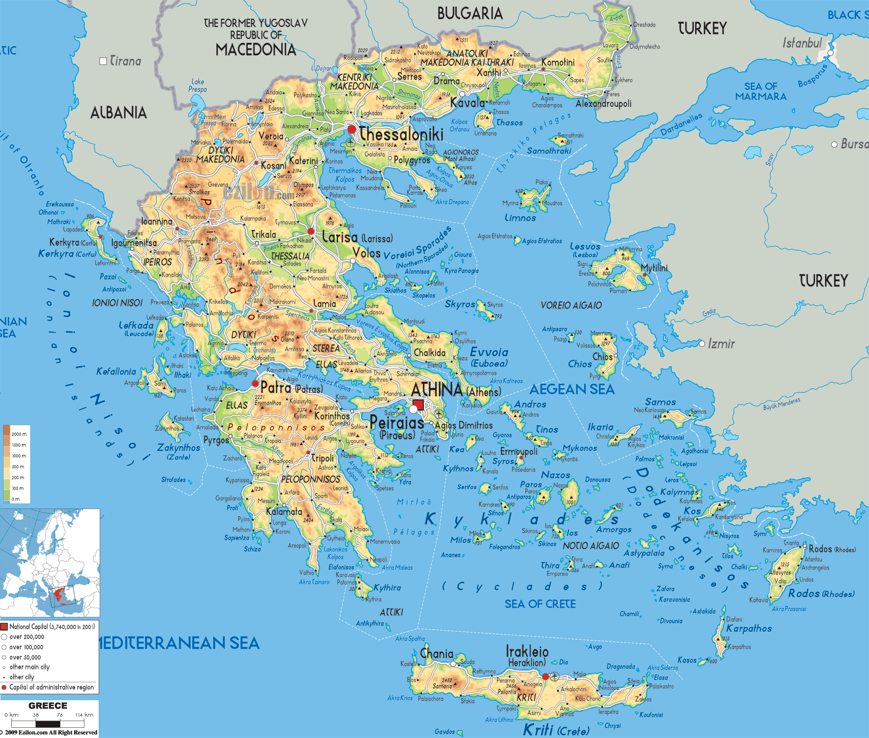
Description: The physical Map of Greece showing major geographical features like islands, elevations, mountain ranges, seas, lakes, plateaus, peninsulas, rivers, plains, landforms and other topographic features.
 Detailed Physical map of Greece showing Pindus Mountains, Islands and Coastline, elevations and other topographic features. Picture yourself on a hill in Greece admiring the unreal-looking dramatic views. It offers lovely sea and mountain views. The ancient mountains rise from the crystal sea like sleeping giants, for between the mountains are fertile valleys, and hundreds of islands lie like emeralds on the horizon. Welcome to Greece, the country with millions of years of history on every angle you see.
It's the consequence of one of the world's great geological dramas and the script is still being written. Greece sits right where the African and European continents are slowly colliding, creating a landscape so diverse and spectacular that it's shaped not just the country's geography, but the entire course of human civilization. From Mount Olympus piercing the sky at nearly 3,000 meters to sun-warmed beaches where the Mediterranean gently laps ancient shores, Greece offers a geographical adventure unlike anywhere else on Earth.
What makes Greece truly special isn't just its beauty - it's how intimately the landscape is woven into daily life. The mountains that once isolated city-states, the ports that launched a thousand ships, the plains that fed great empires: they're all still there and still shape how Greeks live and work and see the world. When we look at Greece's physical geography, we study how rocks and rivers build the destinies of people.
If you've ever wondered what it feels like to stand at the edge of the world, head to the Pindus Mountains in northern Greece. These aren't just hills, they're the geological spine of the entire country, a massive wall of stone that stretches from Albania all the way down to central Greece.
Drive through Western Macedonia and you'll see what I mean. Cities like Kastoria and Grevena nestle in valleys that look like they were carved by the gods themselves. Kastoria sits beside Lake Orestiada like a jewel in a mountain crown, surrounded by peaks that soar over 2,000 meters into often snow-capped skies. The lake itself has a story to tell. It was carved by glaciers during the last ice age when the whole place was frozen.
But the mountains are not just alive with beauty. The shepherds on these valleys, the summits for those who travelled the scams and the streams to have milled grains. Florina at the valley close to the North Macedonian border is a connection between humans and the earth for thousands of years.
Kozani tells a similar story. This city sits in the Aliakmon River valley, and that river is Greece's longest at nearly 300 kilometers - has been the region's lifeline since ancient times. The Aliakmon starts its journey high in the Pindus peaks, tumbles through dramatic gorges, then spreads out to create the fertile plains that have fed northern Greece for generations. Following its path is like reading the biography of the landscape itself.
Even if Mount Olympus isn't specifically labeled on our political map, its presence dominates everything around Thessaloniki and the border between Central Macedonia and Thessaly. At 2,917 meters, this isn't just Greece's tallest mountain - it's a geological masterpiece that perfectly explains why ancient Greeks believed the gods lived here.
Olympus isn't actually one mountain but a whole family of 52 peaks, each with its own personality. The highest, Mytikas, literally means "nose" in Greek - and when you see it jutting into the sky, you'll understand why. But what's really mind-blowing is the mountain's story. Those limestone cliffs and marble faces? Once, the seas flooded this space and formed part of the ancient ocean bed. However, the geological push of continental collision is keeping Greece changing till today.
When you stand at the base of Olympus and look up, you are looking at millenia of earth in rock. The deep gorges were carved by countless storms, the hidden valleys sheltered ancient forests, and the diverse ecosystems. From Mediterranean scrub at the bottom to alpine conditions at the top - create a living laboratory of how elevation shapes life itself.
From Olympus, the land rolls gently down toward Thessaloniki and the Thermaic Gulf. This isn't an accident—three major rivers (the Aliakmon, Axios, and Gallikos) have been depositing fertile soil here for millennia, creating the rich agricultural plains that made this region prosperous enough to support one of Greece's greatest cities.
The Chalkidiki Peninsula is one of those geographical features that makes you wonder if nature has a sense of humor. Three distinct peninsulas—Kassandra, Sithonia, and Athos—stretch into the Aegean like fingers, each with its own geological personality and human story.
Kassandra, the western "finger," is the gentle one. Its rolling hills and coastal plains, formed by soft sedimentary rocks, have made it perfect for both farming and modern tourism. Drive through its olive groves and vineyards, and you're seeing thousands of years of human partnership with a landscape that's naturally generous.
Sithonia, the middle peninsula, has more attitude. With metamorphic rocks creating steeper hills and wilder coastlines, it has a certain impact that makes you want to pull over just to look around. Over millions of years waves build these cliffs giving you secret coves that lead to dramatic headlands.
But Mount Athos, now that's something special. This easternmost peninsula rises straight from the sea to over 2,000 meters, its marble and schist slopes creating one of the most spectacular coastal mountain landscapes in the world. The peninsula's isolation, created by its dramatic geography, has made it perfect for the monastic communities that have called it home for over a thousand years. Geography as destiny, written in stone.
The Rhodopi Mountains along the Bulgarian border create a natural wall that's influenced everything from climate to culture in this corner of Greece. These peaks, visible around cities like Drama and Xanthi, represent the southern edge of the great Balkan mountain system—a reminder that Greece is both Mediterranean and Balkan, both European and uniquely its own.
Drama sits in a sweet spot between the mountains and the coastal plain, giving it access to both highland and lowland resources. It's the kind of location that's been strategically important for thousands of years, and you can still feel that importance when you walk through its streets.
The Nestos River tells one of the region's most dramatic stories. Starting high in the Rhodopi peaks, it carves a spectacular gorge through solid rock before spreading out into one of Greece's most important wetland deltas near Kavala. Following the Nestos from mountain to sea is like taking a crash course in how water shapes landscape—and how landscape shapes life.
Kavala itself sits on a natural harbor protected by Thasos Island, taking advantage of both the sea and the fertile coastal plain created by river sediments. It's a perfect example of how Greek cities have always been positioned to make the most of their geographical advantages.
If you want to understand why Thessaly has been called Greece's breadbasket for over 2,000 years, just stand anywhere in the vast plain around Larisa and look around. This isn't just flat land—it's some of the richest agricultural soil in Europe, created by millions of years of sediment deposited by the Pineios River and its tributaries.
The plain is like a giant natural amphitheater, surrounded by mountains on all sides. To the west, the Pindus Mountains rise like a wall, while to the east, Mount Ossa and Mount Pelion create a barrier between Thessaly and the sea. This ring of mountains has trapped sediments and created a natural basin with soils so fertile that they've supported continuous agriculture since the Neolithic period.
Mount Pelion, stretching into the Aegean near Volos, is pure magic. This mountain peninsula, formed of schist and marble, creates a landscape where traditional stone villages seem to grow right out of the mountainsides. The diverse microclimates here support everything from beach resorts at sea level to cool mountain forests where you can escape the summer heat.
Volos sits where this mountain paradise meets the sea, at the head of the Pagasetic Gulf. The city's natural harbor, protected by the Pelion Peninsula, has made it important since ancient times—this is where Jason and the Argonauts supposedly set sail in search of the Golden Fleece.
Near Kalambaka, the Meteora rock formations create one of the world's most surreal landscapes. The sedimentary rock from an ancient lake that dried up formed these towering 400-meter tall stone pillars from the plain. Erosion has formed them into towers that look impossible. To see the monasteries built on top of these natural skyscrapers is to watch a twinning of human faith and geological wonder.
The sacred Mount Parnassus south of Lamia rising above 2400 m is so heavily enshrined with mythology that the geology is difficult to separate. The limestone massif was generated by the sea beds of an ancient sea that have been pushed upwards which gives rise to stunning cliffs and hidden valleys.
Located high on the slopes of Mount Parnassus, the enormous limestone cave called the Corycian Cave was formed through the underground action of water. The Greeks held this to be sacred to Pan, and when you enter a natural chamber the size of a cathedral you can see why. The sound quality, the pattern of light and shade, and the feeling of being inside the rock make this place a geological spiritual experience.
Delphi, positioned on Parnassus's southern slopes, sits in a natural amphitheater that seems almost too perfect to be accidental. The site straddles a fault line where underground springs emerge - the sacred spring that was central to the ancient oracle. The cliffs towering above and the valleys below provide a theatrical setting that illustrates how Greece's physical fibre has always influenced its spiritual fibre.
The Spercheios River valley creates one of central Greece's most important geographical corridors, connecting the mountains to the Maliakos Gulf. This valley, visible on the map as the lowland between Lamia and the coast, has been a natural highway for thousands of years.
The famous Thermopylae pass, where 300 Spartans made their legendary stand, sits where this valley meets the sea. The pass exists because of a perfect storm of geography - mountain slopes on one side, coastal marshes on the other, creating a narrow corridor that a small force could defend against a much larger army. Geography as military strategy, written in the landscape itself.
Epirus, centered around Ioannina, feels like Greece's last wild frontier. The Pindus Mountains reach their most dramatic heights here, with peaks like Mount Smolikas and Mount Grammos creating a landscape of alpine meadows, pristine forests, and some of the deepest gorges in Europe.
Ioannina sits beside Lake Pamvotis in a natural basin that feels like a hidden world. The lake, fed by underground springs and surrounded by mountains, creates a unique ecosystem in the heart of the highlands. At 470 meters elevation, the city experiences a climate that's part Mediterranean, part continental—supporting everything from olive trees to beech forests.
The Vikos Gorge in the Zagori region is simply breathtaking—one of the world's deepest gorges relative to its width. Carved by the Voidomatis River through solid limestone, it reaches depths of over 1,000 meters while staying incredibly narrow. Hiking through Vikos is like walking through a crack in the earth itself, with walls so high and narrow that the sky becomes a ribbon of blue overhead.
Greece's second longest river, the Acheloos River is 220 km long, and dominates western Greece.
The river begins in the steep Pindus mountains and flows south through a series of spectacular landscapes until it enters the Ionian Sea near Mesolonghi.
Greece's most important wetland ecosystem of the Acheloos Delta is a dynamic, ever-changing maze of channels, islands, and marshes teeming with biodiversity. The hydrology of the delta which is influenced by both the flow of the river as well as the tides creates habitats that are essential to the resident species as well as migrants.
In western Greece, Agrinio occupies one of the most fertile spots in the middle Acheloos valley. Every year floods of the river deposit rich soil in this area which makes it a fertile agricultural land. The area has been agricultural as a result of this for thousands of years. Thus, it has been inhabited by people since ancient times.
The Taygetos Mountains towering above ancient Sparta create one of the most picturesque mountain landscapes in Greece. The highest peak of the range rises to more than 2400m which provided the Spartans with a natural defence.
The limestone and marble peaks make for a stunning contrast. The steep eastern slopes drop dramatically toward the Eurotas River valley where Sparta sits, while the western slopes descend more gradually toward the Messenian Gulf. This asymmetry has created distinct regional cultures on either side of the range.
The Mani Peninsula, extending south from the Taygetos, is one of Greece's most isolated and rugged regions. This narrow peninsula of barren hills and hidden coves has preserved traditional ways of life that have disappeared elsewhere. The famous stone tower houses of Mani aren't just architecture - they're adaptations to a landscape that's both beautiful and harsh.
The Messenian Gulf and its surrounding plains represent some of the Peloponnese's most fertile and beautiful landscapes. Kalamata, sitting at the gulf's head, takes advantage of both the protected harbor and the rich Messenian Plain created by mountain streams carrying fertile sediment.
This is olive country - the combination of Mediterranean climate, fertile soils, and protective mountains creates perfect conditions for olive cultivation. The landscape here, with its silver-green olive groves stretching between mountains and sea, represents the Mediterranean ideal that has inspired artists and writers for centuries.
The Corinthian Gulf is one of the Mediterranean's most geologically active areas - it's actually still widening by several centimeters each year as tectonic forces continue to reshape the landscape. This ongoing geological drama creates hot springs, earthquakes, and dramatic coastal scenery.
Corinth sits at one of the world's most strategic locations - the narrow Isthmus of Corinth that connects the Peloponnese to mainland Greece. At only 6 kilometers wide, this natural bridge has controlled movement between northern and southern Greece for millennia.
The Corinth Canal, cut through solid limestone in the late 19th century, is an engineering marvel that reveals the isthmus's geological structure. Those vertical walls rising 90 meters above the water show you exactly what ancient travelers had to cross to move between northern and southern Greece.
Patras, on the Gulf of Patras, sits where the Glafkos River meets the sea. The city's position, protected by the Ionian Islands and blessed with fertile river plains, has made it one of Greece's most important ports since ancient times.
The Athens Basin is like a natural amphitheater designed for drama—which is fitting, since this is where democracy and theater were born. The basin, surrounded by mountains on three sides and open to the sea on the fourth, creates a unique microclimate and a sense of enclosure that has shaped Athenian culture for over 2,500 years.
Mount Hymettus, rising east of Athens, is famous for its distinctive blue-gray color—the result of marble that's been quarried since ancient times. Mount Penteli, to the northeast, provided the pure white marble for the Parthenon and other classical monuments. Mount Parnitha, the highest peak surrounding Athens, creates the basin's northern boundary and provides crucial watershed protection.
The Saronic Gulf, stretching south from Athens, is actually a drowned river valley system flooded by rising seas. The gulf's islands—Aegina, Poros, Hydra—are the peaks of submerged mountains, creating a complex archipelago that has provided both protection and maritime connections for Athens throughout history.
Piraeus, on its natural peninsula, takes advantage of three separate harbors formed by the irregular coastline. These harbors have been Athens' maritime gateway since ancient times and continue to handle much of Greece's sea traffic today.
Euboea (Evia), separated from the mainland by the narrow Euripus Strait, is essentially a continuation of the mainland mountains. The island's spine reaches over 1,700 meters at Mount Dirfi, creating a landscape that mirrors the adjacent mainland ranges.
The Euripus Strait at Chalkida creates one of the Mediterranean's strangest phenomena—tidal currents that change direction multiple times per day. This puzzled ancient observers and still challenges modern navigation, a reminder that Greece's geography is full of surprises.
Lesvos, with its rolling hills and fertile plains, feels almost continental compared to other Greek islands. The island's Petrified Forest, preserved by volcanic ash 20 million years ago, provides a window into ancient climates and ecosystems—a reminder that these islands have witnessed incredible environmental changes over geological time.
Chios, close to the Turkish coast, is famous for its mastic trees—plants that grow in a unique microclimate created by limestone soils and Mediterranean weather. Samos, separated from Turkey by a narrow strait, rises dramatically from the sea to over 1,400 meters, creating diverse microclimates from sea level to mountain peaks.
The Cyclades are the peaks of a submerged mountain range, with each island having a unique geological personality. The crescent shape of Santorini bears witness to one of the strongest violent volcanic eruptions ever in history.
Naxos as the largest Cycladic island, rises to over a thousand meters height at Mount Zas that consists of high peaks and easy-going valleys. Paros is famous for its white marble, the same as the one used in classical sculptures and buildings. Mykonos, with its granite hills and rocky coastlines, creates the perfect backdrop for its famous white cubic architecture.
Rhodes, the largest Dodecanese island, combines mountainous interior with fertile coastal plains. Mount Attavyros rises over 1,200 meters, creating dramatic landscapes like the Valley of the Butterflies, where thousands of butterflies gather each summer in a microclimate created by a mountain stream.
Kos, near the Turkish coast, has fertile plains that have supported agriculture since ancient times. Karpathos, one of the most mountainous islands, has preserved traditional ways of life in communities isolated by rugged terrain.
Crete is a world unto itself—Greece's largest island and a landscape of extraordinary diversity. The island's three major mountain ranges create distinct regional personalities and some of the Mediterranean's most dramatic scenery.
The White Mountains (Lefka Ori) in western Crete rise over 2,400 meters, creating an alpine landscape that seems impossible so close to Africa. The Samaria Gorge, carved through these mountains by the Samaria River, is one of Europe's longest gorges—a 16-kilometer walk through a crack in the earth that reaches depths of over 500 meters.
Mount Psiloritis (Ida) in central Crete is the island's highest peak and most sacred mountain. The Idaean Cave, high on its slopes, was considered Zeus's birthplace in ancient mythology—a massive limestone cavern that demonstrates how Greece's physical geography has always inspired spiritual wonder.
The Dikti Mountains in eastern Crete create the island's third major range, surrounding the Lasithi Plateau—a high mountain plain at 850 meters elevation that creates a unique agricultural area surrounded by dramatic peaks.
Corfu (Kerkyra) earns its nickname from the lush vegetation supported by abundant rainfall and fertile soils. Mount Pantokrator, rising over 900 meters, creates dramatic landscapes and microclimates that support everything from olive groves to temperate forests.
Kefalonia rises dramatically from the sea to over 1,600 meters at Mount Ainos, which supports one of Greece's last remaining Greek fir forests. The island's limestone cliffs create some of the Mediterranean's most spectacular coastal scenery, including Myrtos Beach—often called one of the world's most beautiful beaches.
Zakynthos combines fertile eastern plains with dramatic western cliffs. Navagio Beach (Shipwreck Beach) sits in a cove surrounded by limestone cliffs over 200 meters high—a landscape so dramatic it seems almost unreal.
Greece's rivers may be small by European standards, but they're crucial to the country's ecology and human geography. The Aliakmon, Acheloos, and Pineios rivers create fertile valleys, spectacular gorges, and important wetland ecosystems.
Lake Trichonida, Greece's largest natural lake, supports important fish populations and serves as a crucial habitat for migratory birds. The Prespa Lakes, shared with Albania and North Macedonia, represent one of Europe's most important transboundary ecosystems.
Greece and Turkey Evros Delta and Thessalonica's Axios Delta are two of Europe's most important wetlands with hundreds of species of birds and a crucial stopover for millions of migratory birds.
Greece's physical geography isn't just a collection of pretty views. it's a living, breathing landscape that continues to shape how people live, work, and dream. Every mountain peak has been a landmark for travelers, every valley has supported communities, every island has been both refuge and stepping stone.
For anyone trying to understand Greece, the landscape is the key. The mountains that formed independent city-states, the ports that set maritime empires afloat, the fertile plains that sustained classical civilization - all are still there, still affecting the way we live right now; often in ways we don't even notice.
You may hike the Samaria gorge, sail the Cyclades or simply sit in a taverna, watching the sun go down behind Mount Taygetos – anywhere, you are in the presence of geography that has inspired people for millennia. Everything we see here, be it a rock or a view, opens another portal responsibly to another time and place. A landscape through which we travel through time and space.
As one studies the physical map of Greece, one sees a country with a rich cultural background that has developed a partnership with nature over the years. The geography not only shapes the landscape but also the spirit.

Political Map of Greece
Political map and map image of Greece.

Road Map of Greece
Road map and map image of Greece.

Regional Directory of United States of America
Information and guide about United States of America and websites with American topics.

Regional Directory of Europe
Information and guide about Europe and websites with European topics.

Regional Directory of Australia
Information and guide about Australia and websites with Australian topics.