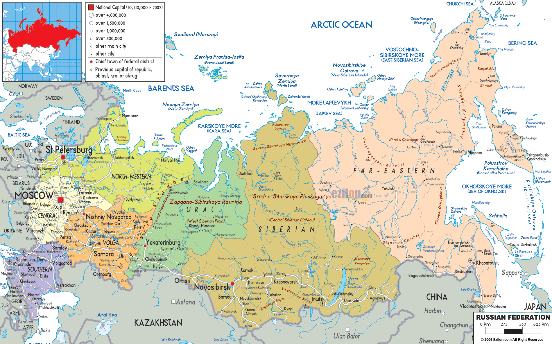
Description: Detailed large political map of Russia showing names of capital cities, towns, states, provinces and boundaries with neighbouring countries.
 Russia is the largest country in the world. It is located on two continents. And it stretches across 11 time zones. This detailed analysis of the political map of Russia uses the attached map to walk readers through every significant region, city, and administrative area. The journey flows from west to east, covering urban centers, federal districts, and bordering nations. If you study geography or even travel, you will want to trace your routes across Eurasia. This map shows the politics of Russia.
Our exploration starts in the North-Western Federal District, bordering Finland, Estonia, and the Baltic Sea. Look closely at the map to see cities like:
St. Petersburg - Russia's second-largest city and a major port on the Gulf of Finland. Historically rich and visually iconic, it's marked with a large dot.
Kaliningrad - An exclave between Poland and Lithuania, disconnected from mainland Russia.
Murmansk, Arkhangelsk, and Petrozavodsk - Important for Arctic access and naval operations.
This district is visually shaded light green and stretches across the Barents Sea in the north to Veliky Novgorod in the south.
The next on the list is the Central Federal District, easily marked on the map as Moscow is the capital of Russia. Look at how dense the city markings are here:
Moscow - Highlighted with a bold square indicating its national capital status. A hub of politics, finance, and culture.
Surrounding cities include Tula, Ryazan, Vladimir, Yaroslavl, Kostroma, and Bryansk.
To the north: Vologda. To the southwest: Kursk, bordering Ukraine.
This region is key to governance and economic output.
Bordering Ukraine, Georgia, and the Caspian Sea, the Southern Federal District is marked in purple and includes:
Rostov-on-Don - Near the Sea of Azov.
Volgograd - Located on the Volga River, once known as Stalingrad.
Astrakhan, Krasnodar, and Sochi - The last sits on the Black Sea, famous for its resort appeal and 2014 Winter Olympics.
Mountains and plains interact here politically and culturally with nearby Caucasus regions.
This orange-shaded region features the Volga River, which snakes through major cities like:
Nizhny Novgorod, Kazan, Samara, Ulyanovsk, and Saratov.
To the southeast, Volgograd connects this region with the Southern District.
The republics of Tatarstan and Bashkortostan are administrative components within.
The map marks this area with numerous city dots, showing its urban density and economic significance.
To the east, the Ural Mountains form the border between Europe and Asia. The Ural Federal District is shown in light green, and encompasses:
Yekaterinburg - A major industrial city east of the Urals.
Chelyabinsk, Perm, Tyumen, and Kurgan - Industrial and energy-focused cities.
Khanty-Mansiysk and Surgut - Marked further north, rich in oil and gas.
The district bridges western urban centers with the resource-heavy east.
Coloured in yellow and light brown, the Siberian Federal District dominates the central section of the map.
Key cities include:
Novosibirsk — Russia’s third-largest city.
Tomsk, Omsk, Krasnoyarsk, Barnaul, and Irkutsk.
In the east, Chita and Ulan-Ude approach the Baikal region.
Major landforms include the Zapadno-Sibirskaya Ravnina (West Siberian Plain) and Sredne-Sibirskoye Ploskogorye (Central Siberian Plateau).
Rivers like the Ob, Yenisei, and Lena snake through this region, and cities line their banks.
Look to the pastel peach section of the map - this is Russia's Far Eastern District. It's a vast area bordered by China, North Korea, Japan, and the Pacific Ocean.
Important cities include:
Khabarovsk and Vladivostok - Near the Sea of Japan.
Yakutsk, Magadan, and Petropavlovsk-Kamchatsky.
Blagoveshchensk sits near the Chinese border.
Note the Kamchatka Peninsula and Kuril Islands reaching into the Pacific. The Far East has strategic military and shipping importance.
North of the mainland, the map shows key archipelagos:
Novaya Zemlya, Franz Josef Land (Zemlya Frantsa-Iosifa), and Severnaya Zemlya.
These lands lie within the Barents Sea, Kara Sea, and Laptev Sea.
Sparse but strategically important, these regions are primarily for military and scientific use.
Russia comprises several types of political units:
Republics like Tatarstan, Bashkortostan, Dagestan, and Yakutia (Sakha).
Krais such as Krasnoyarsk Krai, Primorsky Krai, and Kamchatka Krai.
Autonomous okrugs like Chukotka and Nenets Okrug.
Each region, clearly labeled on the map, has a degree of local governance and is part of a federal district.
Russia's western border touches:
Norway, Finland, Estonia, Latvia, Lithuania, Belarus, and Ukraine.
These regions are shown with dotted lines and visible capital cities like Helsinki, Riga, and Kyiv near the border.
Borders Georgia, Azerbaijan, Kazakhstan, China, Mongolia, and North Korea.
Cities like Barnaul, Kyzyl, and Chita are near these southern peripheries.
You can even see Japan across the Sea of Okhotsk, with Sapporo marked on Hokkaido island.
Some cities line up in corridors, but it’s not the point of this map. This implies rail connectivity.
The Trans-Siberian Railway runs from Moscow to Vladivostok, touching major cities along the way.
Major ports visible include:
St. Petersburg, Murmansk, Arkhangelsk on western seas
Vladivostok, Magadan, Petropavlovsk in the east
Kaliningrad as a key exclave port
These cities are marked with red circles. Some notable ones:
Moscow - Over 10 million people live in the city of Moscow, which male it the largest city in Russia.
St. Petersburg - Over 4 million
Novosibirsk, Yekaterinburg, Kazan, Nizhny Novgorod, Chelyabinsk
These form Russia's urban backbone.
Other significant cities include:
Arkhangelsk, Irkutsk, Tyumen, Yakutsk, Krasnodar, and Ufa.
Grozny in Chechnya, Makhachkala in Dagestan.
Each is labeled with a black dot or circle, and many are administrative seats.
The political map of Russia reveals the story of a huge federation. Every region in Russia, from the thickly populated metropolitan areas in the west to the hardly inhabited border communities in the east, is geopolitically significant.
Studying this map not only helps readers visualise how Russia functions geographically, but also provides insight into trade, defense, culture, and environmental zones.
Whether you're tracing routes for study, planning exploration, or learning how cities and regions connect, this map offers a rich narrative of the world's largest country.

Physical Map of Russia
Physical map and map image of Russia.

Road Map of Russia
Poad map and map image of Russia.

Regional Directory of United States of America
Information and guide about United States of America and websites with American topics.

Regional Directory of Europe
Information and guide about Europe and websites with European topics.

Regional Directory of Australia
Information and guide about Australia and websites with Australian topics.