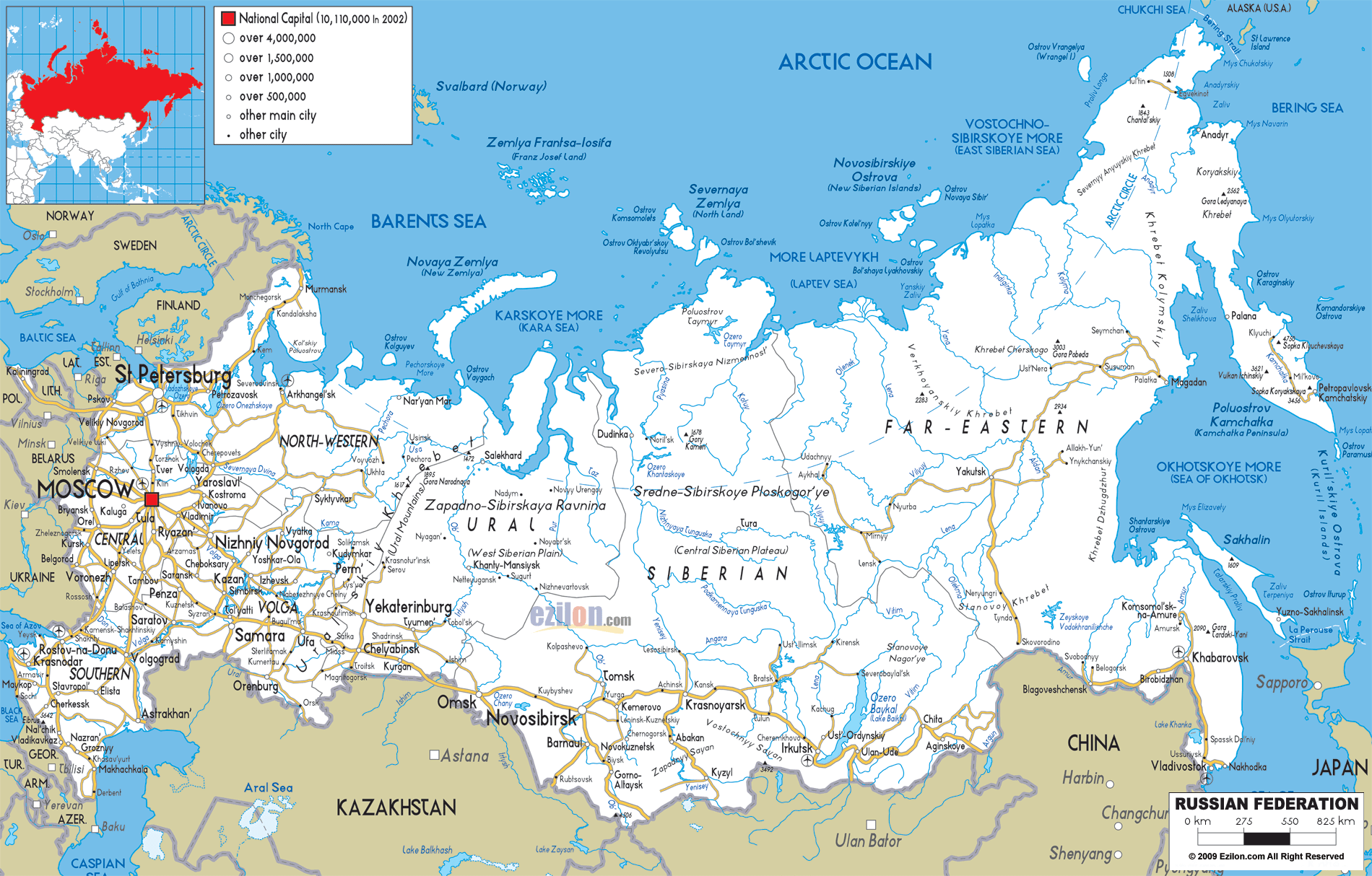
Description: Detailed clear large road map of Russia with road routes from cities to towns, road intersections / exit roads in regions, provinces, prefectures, also with routes leading to neighboring countries.
 Detailed map of Russia with Road Map of Russia with Highways and Expressways connecting cities and towns, with routes extending to the borders of neighboring Norway, Finland, Estonia, Latvia, Lithuania, Poland (Kaliningrad exclave), Belarus, Ukraine, Georgia, and Azerbaijan. Russia's roads stretch from the Baltic Sea to the Pacific Ocean and cover 17 million square kilometers of territory. Road Network of Russia is a guide to each main road, highway and other transport route that appears on the Russian road map. A very valuable resource for traveller, geography student and transportation professional alike in this gigantic country.
Russia's road network operates through a hierarchical system designed to connect major population centers, industrial regions, and international borders. The road infrastructure consists of federal highways, regional roads, and local links which allow travelling across the diverse terrain from the European plain to the Siberian wilderness.
• M-roads are the arterial federal highways between Moscow and the capitals of constituent federal entities. A-roads are alternatives to the M-roads connecting specific corridors. Regional roads are secondary connectors of smaller cities. Local roads are cities and rural areas roads.
Moscow stands as Russia's undisputed transportation center, with major highways radiating in all directions like spokes of a wheel. The capital city, marked prominently on the map, serves as the starting point for most of Russia's major federal highways.
The M-1 travels west from Moscow to the border with Belarus, through: • Smolensk, a historic fortress city and important transportation centre • Vyazma, a significant junction for northern and southern routes • Gagarin, named after the famous cosmonaut.
This highway provides the primary route for traffic traveling between Moscow and Western Europe via Belarus and Poland.
The M-2 heads south from Moscow, connecting: • Tula: Major industrial center with weapons manufacturing heritage • Orel: Regional capital serving central Russia's agricultural areas • Kursk: Historic city famous for World War II battles • Belgorod: Border city connecting to Ukraine
M-3 opens southwestern access from Moscow through: Kaluga, space industry center and regional hub; and Bryansk, border region city with significant industrial activity.
St. Petersburg, Russia's second-largest city and former capital, anchors the northwestern road network. The city connects to:
• Veliky Novgorod: Ancient Russian city accessible via regional highways • Pskov: Historic border city with connections to Estonia and Latvia • Petrozavodsk: Capital of Karelia, gateway to northern wilderness areas
The M10 is the most important of all Russian transport roads and connects the two biggest cities directly: • Distance: 700 km • Major stops: Tver, Torzhok, Valdai • Bulk: It carries enormous passenger and freight traffic.
Roads extend northward from St. Petersburg to: • Murmansk: Arctic port city and naval base • Arkhangelsk: Historic northern port on the White Sea • Petrozavodsk: Regional center serving Karelia's forests and lakes
The Volga River region contains some of Russia's most important cities, all connected by extensive road networks that parallel the great river's course.
Nizhny Novgorod serves as a major junction where several highways converge: • M-7 Volga Highway: Connects Moscow to Kazan and beyond • Regional roads to Kirov and northern territories • Southern connections to Penza and Saratov
The medium-volga areas of Tatarstan and neighbouring regions are Served by Kazan as follows: M-7 link to Moscow; E. Links to Ufa and the urals; N. connections to Kirov and Syktyvkar.
Samara (formerly Kuibyshev) serves as a major Volga region hub: • M-5 Ural Highway passes through the city • Connections to Saratov and Volgograd to the south • Eastern routes toward Orenburg and Kazakhstan
Volgograd (formerly Stalingrad) anchors the southern Volga transportation network: • M-6 Caspian Highway connects to Astrakhan • Western routes to Rostov-on-Don • Eastern connections toward Kazakhstan
Astrakhan serves as the southern terminus of the Volga transportation corridor: • M-6 provides connection to Volgograd and northern cities • Regional roads serve the Volga Delta region • International connections toward Iran and Central Asia
The Ural Mountains region constitutes the geographical and transportation divide between European and Asian Russia. Furthermore, they are connected by an extensive network of roads featuring major industrial cities.
Yekaterinburg stands as the unofficial capital of the Urals and a major transportation hub: • M-5 Ural Highway provides direct connection to Moscow • M-36 extends eastward toward Chelyabinsk • Northern routes to Perm and Syktyvkar • Southern connections to Kurgan and western Siberia
Perm serves the northern Ural region with connections to: • Syktyvkar: Capital of the Komi Republic • Kirov: Junction city connecting to central Russia • Yekaterinburg: Southern Ural connection
Chelyabinsk anchors the southern Ural transportation network: • M-36 connects to Yekaterinburg • M-5 continues eastward toward Kurgan • Southern routes toward Orenburg and Kazakhstan
Ufa serves as the capital of Bashkortostan and important regional hub: • Connections to Samara and the Volga region • Eastern routes toward Chelyabinsk • Southern connections to Orenburg
Western Siberia contains Russia's most important east-west transportation corridor, anchored by the Trans-Siberian Railway and parallel highway systems.
Tyumen serves as the first major Siberian city encountered when traveling east: • M-51 Baikal Highway begins the great Siberian journey • Connections to Yekaterinburg and the Urals • Northern routes to oil and gas fields
Omsk represents a major junction in the western Siberian transportation network: • M-51 continues the Trans-Siberian highway route • M-38 provides northern connections • Southern routes toward Kazakhstan border cities
Novosibirsk, Siberia's largest city, serves as the region's transportation capital: • M-52 Chuysky Tract extends southward toward the Altai Mountains • M-53 continues eastward toward Krasnoyarsk • M-51 provides the main Trans-Siberian connection • Regional roads serve the Kemerovo industrial region
Kemerovo anchors the Kuzbass (Kuznetsk Basin) industrial region: • Connected to Novosibirsk via regional highways • Novokuznetsk: Major industrial city within the region • Tomsk: University city and regional center to the north
Barnaul serves as the capital of Altai Krai: • M-52 provides connection to Novosibirsk • Southern routes toward the Altai Mountains • Border connections toward Kazakhstan
Central Siberia, dominated by the Yenisei River system, presents unique transportation challenges due to vast distances and harsh climate conditions.
Krasnoyarsk serves as the major transportation center for central Siberia: • M-53 continues the Trans-Siberian highway eastward • M-54 extends northward toward the Arctic • Regional connections to Abakan and southern territories
Abakan serves as the capital of Khakassia: • Connected to Krasnoyarsk via regional highways • Southern routes toward the Sayan Mountains • Access to Kyzyl and the Tuva Republic
The vast northern territories are served by limited road networks: • Norilsk: Arctic mining city with seasonal road access • Dudinka: Port city on the Yenisei River • Igarka: Northern timber center
The Lake Baikal region represents a crucial link in Russia's transcontinental transportation network, connecting central Siberia with the Far East.
Irkutsk serves as the major city in the Baikal region: • M-53 provides the main Trans-Siberian connection • M-55 extends northward toward Bratsk • Southern routes toward Ulan-Ude and Mongolia
Bratsk represents a major industrial city north of Lake Baikal: • Connected to Irkutsk via M-55 • Ust-Ilimsk: Northern industrial center • Regional roads serve the Angara River valley
Ulan-Ude serves as the capital of the Buryat Republic: • M-55 provides connection to Irkutsk • A-340 extends toward the Mongolian border • Eastern routes toward Chita and the Far East
Chita anchors the Trans-Baikal transportation network: • M-58 continues the Trans-Siberian route eastward • Southern connections toward Mongolia • Regional roads serve mining and agricultural areas
The distance is huge, the terrain is mountainous, and the climate is very cold, this is the Russian Far East's transport challenge!
Khabarovsk serves as the major transportation center for the Far East: • M-58 provides the Trans-Siberian connection • M-60 extends southward toward Vladivostok • A-375 heads northward toward Komsomolsk-on-Amur
Vladivostok, Russia's principal Pacific port, anchors the Far Eastern transportation network: • M-60 provides connection to Khabarovsk • A-370 serves the Primorsky Krai region • International connections to China and North Korea
Komsomolsk-on-Amur represents a major industrial city in the northern Far East: • Connected to Khabarovsk via A-375 • Regional roads serve the Amur River valley • Limited connections to northern territories
Blagoveshchensk serves as the capital of Amur Oblast: • M-58 provides Trans-Siberian connection • Border crossing to China across the Amur River • Regional roads serve agricultural areas
Northern Russia's transportation infrastructure faces extreme challenges due to permafrost, harsh climate, and vast distances between settlements.
Murmansk, the world's largest city north of the Arctic Circle: • M-18 provides connection to St. Petersburg • Regional roads serve the Kola Peninsula • Apatity and Kirovsk: Mining centers in the region
Arkhangelsk serves as a major northern port city: • M-8 connects to Moscow via Vologda • Severodvinsk: Shipbuilding center nearby • Regional roads serve northern forest areas
Syktyvkar anchors transportation in the Komi Republic: • Connections to Perm and the Urals • Ukhta: Oil and gas center to the north • Vorkuta: Arctic mining city with limited road access
Salekhard serves the Yamal Peninsula gas fields: • Seasonal road connections to southern cities • Novy Urengoy: Major gas production center • Limited year-round road infrastructure
Southern Russia's road networks connect the fertile steppe regions with the Caucasus Mountains and provide international connections to neighboring countries.
Rostov-on-Don serves as the major transportation center for southern Russia: • M-4 Don Highway provides connection to Moscow • M-19 extends toward the Caucasus region • Regional roads serve the Don River valley
Krasnodar anchors the Kuban region transportation network: • M-25 connects to Rostov-on-Don • A-146 provides access to Sochi and the Black Sea coast • Regional roads serve agricultural areas
Sochi, site of the 2014 Winter Olympic Games, is delivered with coastal highway connections by A-147. Road connections leading to the mountains provide access to ski resorts and recreational area. Road connections are limited due to the mountainous nature of the landscape.
Stavropol serves the North Caucasus region: • A-157 connects to Rostov-on-Don • Regional roads serve Pyatigorsk and spa towns • Mountain routes toward the Caucasus republics
Russia has very long and extensive borders. They are in very much need of complicated transport connections so that they can trade and travel internationally.
• Finland: Connections through St. Petersburg and border crossings Estonia/Latvia: along Pskov and north-western line Belarus: road M-1 and numerous border crossing Ukraine: roads M-2 and M-3 and many border crossings.
• Georgia: Limited mountain crossings in the Caucasus region • Azerbaijan: Connections through Dagestan and the Caspian region • Kazakhstan: Multiple crossings including routes from Orenburg, Chelyabinsk, and Omsk
• Mongolia: Crossings via Ulan-Ude and Kyakhta • China: Major crossings at Blagoveshchensk, Khabarovsk, and Vladivostok • North Korea: Limited crossing near Vladivostok
Due to Russia’s largeness and differing climate conditions, road networks face one-of-a-kind challenges.
• Northern territories require specialized road construction techniques • Seasonal accessibility limits year-round transportation • Yakutsk and other northern cities rely on winter roads and air transport
• Caucasus Mountains have a limited number of passes and seasonal closures. Ural Mountains have a good infrastructure but are affected by the weather. Altai Mountains have beautiful sights but have limited capacity.
• Major rivers require substantial bridge infrastructure • Volga, Yenisei, Lena, and Amur rivers present engineering challenges • Ferry services supplement bridge connections in remote areas
Roads are an important activity of the Russian economy and play a key role.
• Oil and gas pipelines parallel major highway corridors • Mining regions require specialized transportation infrastructure • Agricultural products move via road networks to processing centers and ports
• Trans-Siberian Highway attracts international adventure travelers • Golden Ring routes near Moscow serve cultural tourism • Altai and Baikal regions depend on road access for eco-tourism
• Highway connections influence city growth patterns • Industrial centers develop around transportation hubs • Regional capitals serve as distribution centers for surrounding areas
Russia is putting more money into improving its roads to help the economy.
• Upgrading existing M-roads to modern standards • Expanding capacity on high-traffic corridors • Improving safety and weather resistance
• The objective is to establish a direct connection between remote communities and the highway network of the Federation Develop alternative routes to reduce dependence on single corridors Improve border crossing facilities.
• Modern traffic management systems • Weather monitoring and road condition reporting • Electronic toll collection and vehicle tracking
When rated in relation to other countries, Russia has one of the largest and most complicated road networks in the world. The service roads in Moscow, Siberia and beyond help the road tenders and contractors in completing construction or repair works without obstructing vehicular traffic.
Reading this network means to appreciate its accomplishments as well as its failures. The Trans-Siberian Highway and other main corridors give a reliable connection a long way and for long distances. However, many areas still rely on seasonal roads or other means of transport.
Russia's road map is important for travelers, geography students, and transportation professionals as it shows how infrastructure affects settlement patterns. Whether you're going to travel a long distance across the country or studying some regional geography, it has a network that is still being developed for some time.
The roads of Russia tell the story of a nation spanning continents, linking ancient cities with modern industrial centers, and providing pathways for exploration across some of Earth's most spectacular and challenging landscapes.

Physical Map of Russia
Physical map and map image of Russia.

Political Map of Russia
Political map and map image of Russia.

Regional Directory of United States of America
Information and guide about United States of America and websites with American topics.

Regional Directory of Europe
Information and guide about Europe and websites with European topics.

Regional Directory of Australia
Information and guide about Australia and websites with Australian topics.