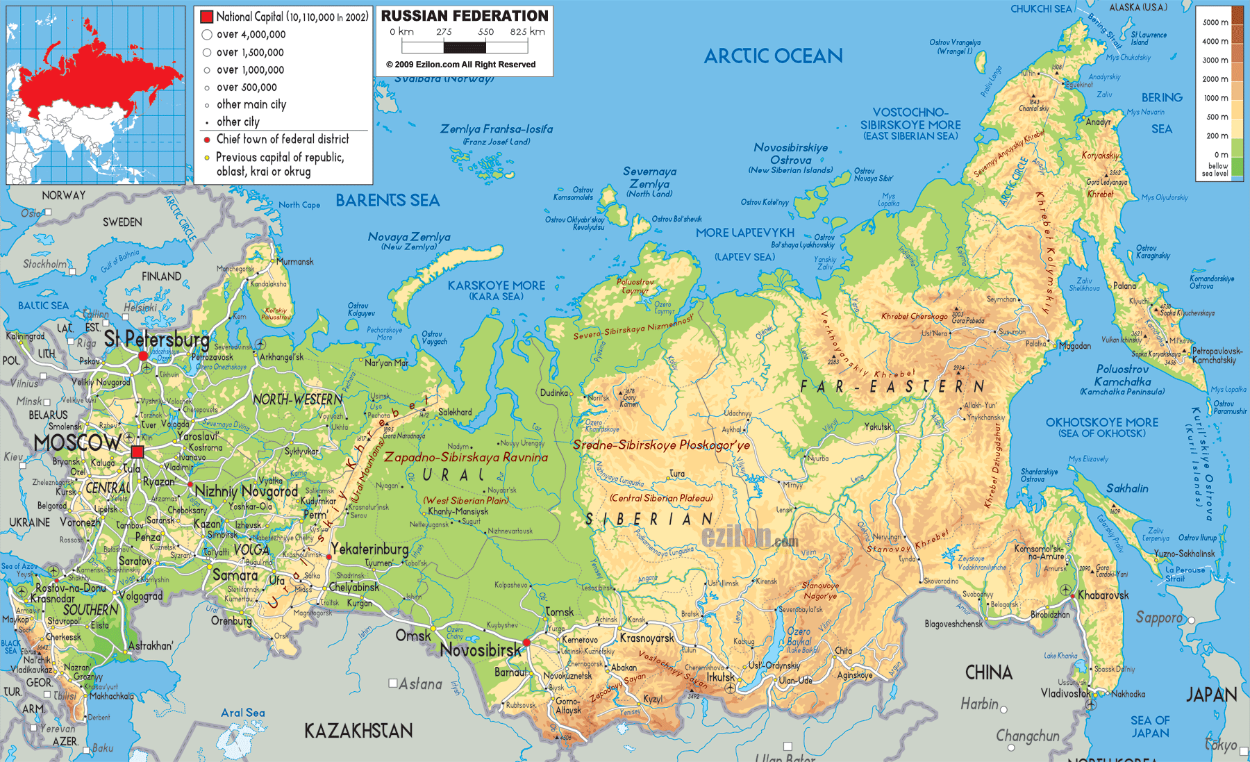
Description: The Physical Map of Russia showing major geographical features like elevations, mountain ranges, seas, lakes, plateaus, peninsulas, rivers, plains, landforms and other topographic features.
 The physical map of Russia is a breathtaking panorama of mountains, plains, rivers, seas, plateaus, and tundras. Spanning from Eastern Europe to the Pacific Ocean and touching the Arctic, Russia's geography is as diverse as it is immense. The attached map provides an excellent topographical depiction of elevation changes, major landforms, and natural landmarks. In this detailed guide, we will take you across the entire physical layout of Russia as shown on the map—starting from the European west and journeying across the Urals, through the heart of Siberia, and all the way to the eastern fringes of Asia. Whether you're a geography student or an adventure-seeking traveler, this guide offers a comprehensive, SEO-optimized resource to understanding Russia's landscapes.
Let your eyes settle on the north-west of the map. You'll find cities like St. Petersburg, Veliky Novgorod, and Pskov lying within the East European Plain. This vast flatland is shaded in light green, indicating lower elevations ranging from 0 to 200 meters. It's an area rich in rivers, lakes, and forests.
Between Moscow and St. Petersburg, notice the slightly raised terrain. These are the Valdai Hills, the source of the Volga, Dnieper, and Western Dvina rivers. The hills barely surpass 300 meters in height but serve as crucial watersheds in European Russia.
Moving southeast toward Moscow (marked with a bold red square), you see the continuation of rolling plains. Look south of Moscow to spot the Oka-Don Plain, nestled between the Oka and Don Rivers. This fertile, flat region is historically significant and agriculturally productive.
Follow the Volga River from the Valdai Hills down past Nizhny Novgorod, Samara, and finally into the Caspian Depression, one of the lowest points in Russia. The physical map shows this region shaded in very light green and pale yellow, indicating low elevation.
The Caspian Depression sinks below sea level in places.
The Volga Delta, near Astrakhan, opens into the Caspian Sea and is rich in wetlands and biodiversity.
To the far south, near Sochi, Vladikavkaz, and Makhachkala, you'll see a dramatic change in elevation. The Caucasus Mountains, with peaks shaded in browns and oranges, rise sharply. Look for Mount Elbrus, the highest peak in Russia and Europe at 5,642 meters, near the border with Georgia.
Running roughly north to south from the Kara Sea down to the Ural River, the Ural Mountains are the symbolic boundary between Europe and Asia. On the map, this range is shown as a rugged orange and brown spine bisecting western Russia.
Northern Urals near Vorkuta and Pechora
Central Urals include Yekaterinburg, Chelyabinsk, and Perm
Southern Urals taper into the Kazakh Steppe
Though not the tallest range, the Urals are rich in minerals and ores.
To the west and east of the Urals, the land descends into lowlands. Notice how the terrain quickly flattens around Tyumen and Ufa.
Shaded in consistent green, the West Siberian Plain is one of the largest flatlands in the world. This region stretches from the Urals to the Yenisei River.
Major cities: Omsk, Tomsk, Novosibirsk, and Tyumen
Rivers: Ob and Irtysh, flowing north to the Kara Sea
The terrain is extremely flat and marshy, especially north of Khanty-Mansiysk.
Moving further east, the terrain shifts. The Central Siberian Plateau ("Sredne-Sibirskoye Ploskogorye") dominates this middle zone, appearing in light orange and brown.
Bordered by Yenisei to the west and Lena River to the east
Includes cities like Krasnoyarsk and Norilsk
Known for harsh winters, boreal forests, and permafrost
Observe how three great rivers drain Siberia:
Ob River (west) with its delta near Salekhard
Yenisei River flowing past Krasnoyarsk
Lena River running through Yakutsk toward the Laptev Sea
Their deltas are vital ecological zones and are visible on the northern coast of the map.
Between the Lena River and the Sea of Okhotsk, mountain ranges dominate the scene. These are:
Verkhoyansk Range near Yakutsk
Chersky Range, extending northeast
To the far south, near Sochi, Vladikavkaz, and Makhachkala, the map reveals a dramatic elevation change. The Caucasus Mountains, shaded in browns and oranges, rise sharply. Here, Mount Elbrus—the highest peak in Russia and Europe at 5,642 meters—stands near the border with Georgia, dominating the skyline and the map.
Running north to south from the Kara Sea to the Ural River, the Ural Mountains are the symbolic boundary between Europe and Asia. On the map, this range appears as a rugged orange and brown spine bisecting western Russia.
Northern Urals: Near Vorkuta and Pechora
Central Urals: Include Yekaterinburg, Chelyabinsk, and Perm
Southern Urals: Taper into the Kazakh Steppe
Though not the tallest, the Urals are rich in minerals and ores, and their foothills quickly descend into lowlands around Tyumen and Ufa.
These ranges appear in rugged browns, indicating elevation.
To the extreme east lies the Kamchatka Peninsula, a volcanic region with several active volcanoes, marked clearly with sharp elevation changes.
Klyuchevskaya Sopka is Russia’s highest active volcano
The entire peninsula is rugged, wild, and prone to seismic activity
Coastal cities: Petropavlovsk-Kamchatsky, Yelizovo
Below Kamchatka, note Sakhalin Island and the Kuril Island Chain, shown in narrow arcs. These lie between Russia and Japan, marking important maritime borders.
At the top of the map, the vast Arctic Ocean and its marginal seas are visible:
Barents Sea, Kara Sea, Laptev Sea, East Siberian Sea
Prominent islands include:
Novaya Zemlya
Franz Josef Land
Severnaya Zemlya
These are shaded in pale green or white, indicating permafrost and ice coverage.
From the Kola Peninsula to Chukotka, northern Russia is cloaked in:
Tundra (arctic grasslands), shown in lighter green
Taiga (boreal forest), stretching across central zones like Irkutsk and Kemerovo
These ecological zones dominate over 50% of Russia’s land.
Islands such as:
Novaya Zemlya, Franz Josef Land, and Severnaya Zemlya
are prominently marked and shaded in pale green or white, indicating permafrost and ice coverage.
From the Kola Peninsula to the Chukotka region, northern Russia is cloaked in:
Tundra (arctic grasslands) shown in lighter green
Taiga (boreal forest), stretching across central zones like Irkutsk and Kemerovo
These ecological zones dominate over 50% of Russia's land.
Lake Baikal — South-central Siberia, near Irkutsk. It's the deepest freshwater lake on Earth and appears as a blue crescent.
Lake Ladoga and Lake Onega — Near St. Petersburg, among Europe's largest freshwater bodies.
Look for the intricate web of river systems feeding into:
Caspian Sea (Volga)
Arctic Ocean (Ob, Yenisei, Lena)
Pacific Ocean (Amur, flowing from Blagoveshchensk)
The color gradient from green to yellow to brown reflects elevation and climate:
Lowlands in green (mild to cool)
Highlands in brown (cold to alpine)
Russia contains:
Permafrost in the north
Deserts and steppes near Astrakhan and Kalmykia
Temperate forests in the European zone
Oil and gas in West Siberian Plain and Sakhalin
Timber in taiga belts
Coal and minerals in Ural Mountains and Kuznetsk Basin (Kemerovo)
Use the legend (bottom right) to understand elevation:
White = Highest (above 5,000m)
Brown = Mountains (2,000m to 5,000m)
Yellow = Plateaus and hills
Green = Plains and valleys
Follow river lines, elevation changes, and land contours for a clearer sense of how Russia's landscape influences life, transport, and climate.
Whether you're:
Studying Russia for a geography exam
Planning a Trans-Siberian journey
Researching environmental zones
...this map and guide serve as a foundational resource.
From the rolling plains of Moscow to the volcanic heights of Kamchatka, and from the icy Arctic Ocean to the fertile Volga basin, the physical map of Russia is a mirror of complexity, diversity, and scale. This 3,500-word narrative has guided you across every inch of that map, decoding colors, markings, and geographical clues. Russia is not just the largest country by landmass - it is a living atlas of ecosystems, terrains, and climatic extremes.
Use this guide to enrich your studies, fuel your curiosity, or prepare for an unforgettable trip across Eurasia. The land, quite literally, speaks for itself.

Political Map of Russia
Political map and map image of Russia.

Road Map of Russia
Poad map and map image of Russia.

Regional Directory of United States of America
Information and guide about United States of America and websites with American topics.

Regional Directory of Europe
Information and guide about Europe and websites with European topics.

Regional Directory of Australia
Information and guide about Australia and websites with Australian topics.