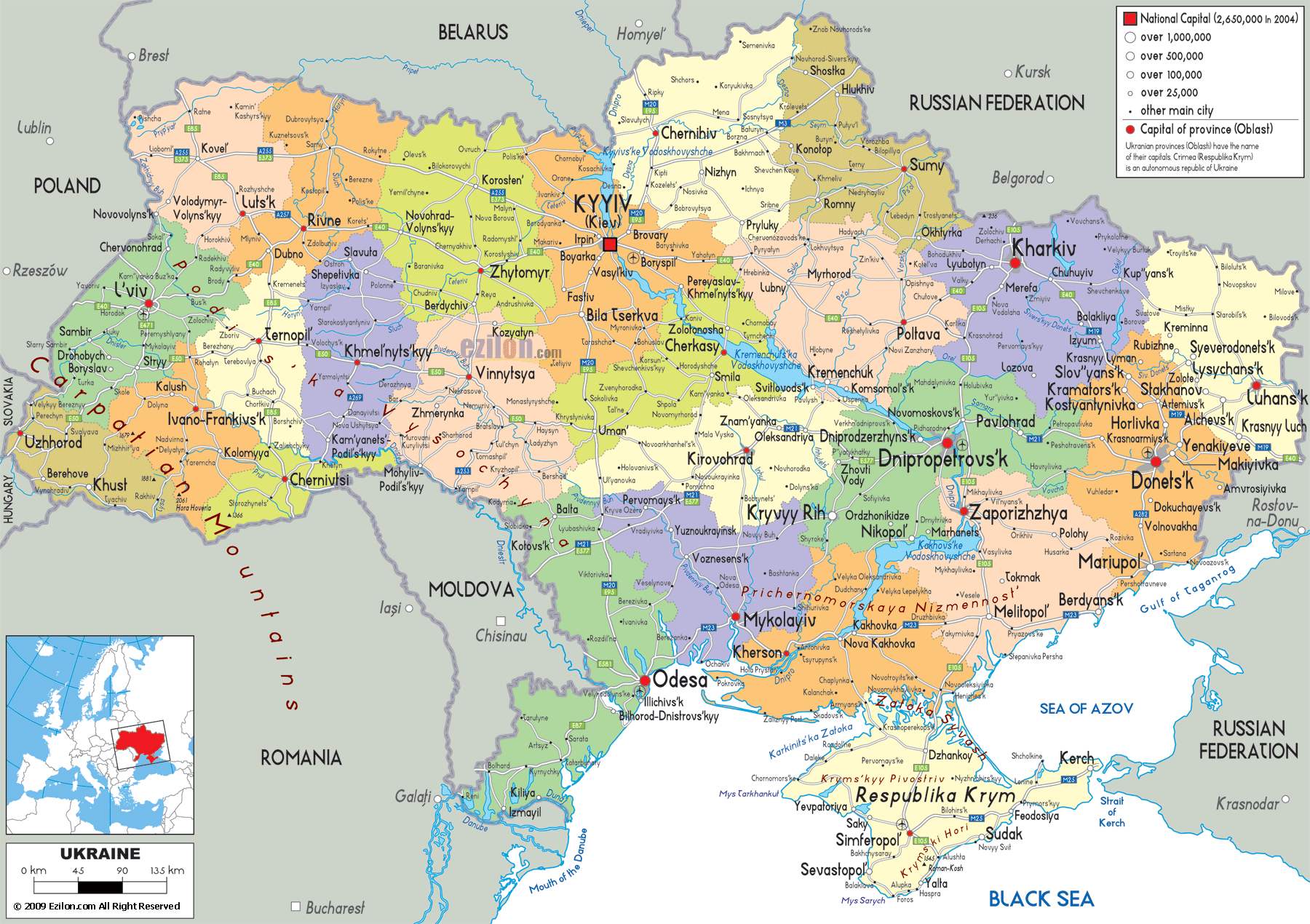
Description: Detailed large political map of Ukraine showing names of capital cities, towns, states, provinces and boundaries with neighbouring countries.
 Ukraine is the second biggest European country after Russia and has a very interesting political geography. As evident from the political map of Ukraine, the country contains 24 provinces. Furthermore, the country also has one autonomous republic i.e. Crimea. Moreover, there are also Two Special Status Cities i.e. Kyiv and Sevastopol. This map is full of colors representing an administrative division, along with the names of cities printed in it.
Ukraine stretches from the Carpathian Mountains to the steppe lands of the Black Sea. Also, it covers the northern plains to the industrial east. Moreover, the political boundaries of this country enclose a cultural and geographical diversity.
Looking at the map of Ukraine's political divisions, you'll notice it shares borders with Poland, Slovakia, Hungary, Romania, Moldova, Belarus, and the Russian Federation. Water boundaries include the Black Sea, the Sea of Azov, and several major rivers like the Dnipro (Dnieper), which flows through the heart of the country, dividing it almost symmetrically.
Ukraine's location in the Eastern European Plain makes it a crossroads of trade, migration, and cultural exchange. This political map depicts political boundaries but is also useful to travelers to find important transport routes, seacoast access points and neighboring connection.
In the far west, bordering Poland, the Lviv Oblast is a historic and cultural jewel. On the map, Lviv is prominently marked as the oblast capital, and you can see its position as a hub of roads radiating toward both Poland and the rest of Ukraine. Lviv is known for its preserved old town, and cultural bridge between Europe and Ukraine.
Nearby cities such as Drohobych, Sambir, and Chervonohrad can also be spotted. The map shows the Carpathian foothills creeping into the southwestern part of the oblast, giving it a mix of mountainous and plain terrains.
Tucked into Ukraine's southwestern corner, Zakarpattia shares borders with Slovakia, Hungary, and Romania. On the map, Uzhhorod stands out as the administrative center. This oblast is the only part of Ukraine entirely on the Carpathian’s southwestern slope. You'll see winding roads cutting through valleys and leading toward mountain passes into Central Europe, vital for both trade and tourism.
Just east of Zakarpattia, Ivano-Frankivsk oblast (with its capital city of the same name) lies in the heart of the Carpathians. The map shows mountainous terrain dominating the southern section, home to Ukraine's highest peak, Hoverla, although the administrative map marks cities rather than relief. The proximity to the Romanian border is visible, making it a cultural mix zone.
Chernivtsi region combines instead of Romania and Moldova on the map. The regional centre Chernivtsi is located on the Bank of the Prut. This oblast is small, but it is full of architecture like nice hotels. As the Balkans' gateway, road links extend south and the map demonstrates this clearly.
Moving slightly northeast, Ternopil is a landlocked oblast with Ternopil city at its center. The Proximity of Lviv, Khmelnytskyi, Ivano-Frankivsk, etc. puts It in the Western Agricultural Region as per the map.
In the northwest, Volyn Oblast borders Poland and Belarus. Lutsk, its capital, appears prominently on the map, connected by road routes to Lviv and Rivne. The map shows its position in the flat Polesia region, known for wetlands and forests.
Just east of Volyn, Rivne oblast has its capital in Rivne city, with map connections leading toward Kyiv, Lviv, and Belarus. This oblast's economy is tied to agriculture, forestry, and amber mining.
South of Rivne, Zhytomyr is marked as its capital city in bold type. The map indicates major highways that run through Kyiv. It is an important transport corridor between western Ukraine and the capital.
At the center of the map, Kyiv stands out in red as the national capital. It straddles the Dnipro River, with bridges connecting the right and left banks. Kyiv is surrounded by Kyiv Oblast, which includes towns like Bila Tserkva and Brovary. The map shows dense road and rail connections radiating from the city, underlining its role as Ukraine's political and cultural heart.
North of Kyiv, Chernihiv oblast borders Belarus and Russia. On the map, the city of Chernihiv appears along the Desna River. This place is important because it has many medieval sites in this region and land.
South of Kyiv, Cherkasy lies on the central Dnipro. The map highlights its location as a mid-point along the river, vital for shipping and agriculture.
East of Cherkasy, Poltava is central in eastern Ukraine. The map shows the location of Poltava city that lies between Kyiv and Kharkiv. It well known for the battle of 1709.
In the southwest, Odesa stands out as Ukraine’s largest Black Sea port. The map shows the oblast extending along the coastline, with cities like Bilhorod-Dnistrovskyi and road routes toward Moldova and Romania. The Danube Delta is visible in the far southwest, marking the border with Romania.
East of Odesa, Mykolaiv is shown at the confluence of the Southern Bug River. The map highlights its shipbuilding importance and proximity to the Black Sea.
Further east, Kherson borders both the Black Sea and Crimea. The map shows the Dnipro delta spreading here, along with key road connections toward the Crimean Peninsula.
Looking eastward on the map, one of the most expansive regions is Dnipropetrovsk Oblast (officially Dnipropetrovs’k). The city of Dnipro is clearly labeled as the provincial capital and serves as a powerhouse of industry, transportation, and culture. You'll see its strategic position along the middle Dnipro River, with highways and rail lines linking it to Kyiv, Zaporizhzhia, and Kryvyi Rih.
The oblast's industrial hubs - Pavlohrad, Kamianske, and Kryvyi Rih - are all visible on the map. The long shape of Kryvyi Rih indicates that it is a mining belt. The density of roads here plays an important part in the country's economy.
Further east, Donetsk Oblast is shaded on the map with key cities like Donetsk, Mariupol, Kramatorsk, and Horlivka. This is Ukraine's heavy industry base, with coal mines and steel plants. Along the southern edge, Mariupol's position on the Sea of Azov is marked - an essential port for metallurgy exports.
You'll also notice on the map the intricate rail network here, a sign of its industrial density. The oblast borders Russia to the east, with crossings indicated by road symbols.
Russia borders northeast of Donetsk, Luhansk Oblast. The provincial capital is Luhansk city. Other centres include Alchevsk and Krasnyi Luch. The map displays great deal of countryside along with urban industrial clusters, such as a mix of agriculture and mining.
To the south of Dnipropetrovsk lies Zaporizhzhia Oblast, with Zaporizhzhia city situated along the Dnipro River just below the massive Dnipro Hydroelectric Power Station (its approximate location aligns with the river crossing seen on the map). The map also highlights Melitopol and Berdyansk, with Berdyansk hugging the Sea of Azov coast.
Kharkiv Oblast, situated north of Donetsk and Luhansk and bordering with Russia, is dominated by the city of Kharkiv, Ukraine's second city. Kharkiv on the map has roads and railways spread throughout Ukraine and other directions. These oblast is famous for its universities, machinery industry, and cultural heritage.
On the map, the Autonomous Republic of Crimea is a pale yellow peninsula jutting into the Black Sea, connected to mainland Ukraine by the narrow Isthmus of Perekop. Simferopol is marked as the administrative capital, while coastal resort cities like Yalta, Sevastopol, and Feodosiya are also visible.
Crimea’s geography is striking even on this political map - mountain ranges in the south, fertile plains in the north, and a long coastline with bays and capes. Sevastopol, a separate city with special status, is also marked here.
Sumy Oblast sits along the northeastern border with Russia. Sumy city is the administrative center, and the map shows towns like Konotop and Shostka linked by a network of roads. This oblast is primarily agricultural, with rolling plains and river valleys.
While already mentioned in Part 1, it's worth noting that the map places Poltava in a strategic position connecting Kyiv to Kharkiv. Its fertile lands are part of Ukraine’s “breadbasket.”
Right in the geographical center of Ukraine, Kirovohrad Oblast (capital: Kropyvnytskyi) is an inland region. On the map, you can see its web of roadways linking to Odesa, Kyiv, and Dnipro. This makes it a critical transit zone.
Located west of Kirovohrad and east of Khmelnytskyi, Vinnytsia appears in bold on the map as the oblast capital. Known for agriculture and sugar production, it has a road network directed toward Kyiv, Odesa, and Moldova.
These three southern oblasts dominate Ukraine's coastline. The way the map shows Odesa's position as a Black Sea hub; Mykolaiv's shipyards; and Kherson's access to Crimea and the Dnipro delta demonstrates Russia's justifications for invading Ukraine on 24 Feb 2022. Together, they form Ukraine's maritime lifeline.
The political map of Ukraine shows that every oblast of the country has its unique identity that is formed by geography, history and economic function. Ukraine is actually a country of regions; from the western mountain passes to the central agricultural plain and the eastern industrial corridor. For an excursionist this map helps uncover historic cities, sea side resorts, and rural scenery. To a student, it is a model of the administrative setup and international relations of the country.

Physical Map of Ukraine
Physical map and map image of Ukraine.

Road Map of Ukraine
Road map and map image of Ukraine.

Regional Directory of United States of America
Information and guide about United States of America and websites with American topics.

Regional Directory of Europe
Information and guide about Europe and websites with European topics.

Regional Directory of Australia
Information and guide about Australia and websites with Australian topics.