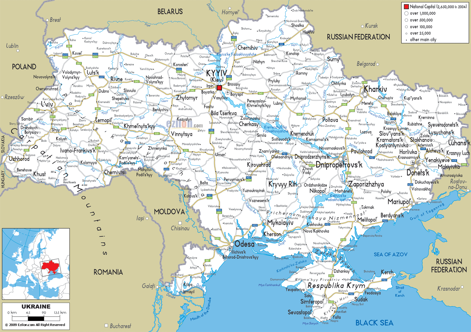
Description: Detailed clear large road map of Ukraine with road routes from cities to towns, road intersections / exit roads in regions, provinces, prefectures, also with routes leading to neighboring countries.
 When you first lay your eyes on the road map of Ukraine in front of you, the complex network of highways, national routes, and regional roads immediately stands out. From the Carpathian Mountains in the west to the vast steppe lands in the east, Ukraine’s road infrastructure is not just a system of travel - it’s the connecting thread that links diverse landscapes, cultures, and economic hubs.
This map shows every significant motorway, regional road, and urban connection, making it valuable for geography students, logistics planners, and travelers preparing to drive across Ukraine. You can clearly see how national roads (M-routes) link major cities like Kyiv, Lviv, Odesa, Kharkiv, and Dnipro, while regional P- and H-routes connect smaller towns and rural areas.
Looking at the western edge of the map, Ukraine shares borders with Poland, Slovakia, Hungary, and Romania, and this is where many international road routes begin or end.
In the northwest corner, the E40 European route comes in from Poland’s Rzeszów region into Lviv, one of Ukraine’s most important cultural and historical cities. This E40 corridor is a vital artery, forming part of the international road network linking Western Europe to Ukraine’s heartland.
From Lviv, you can see multiple road lines radiating outward:
M06 Highway heading northeast toward Rivne and onward to Kyiv.
M09 Highway leading toward Ternopil and connecting southwards.
M11 Route heading west into Poland, an essential crossing point for both commercial and passenger traffic.
Zoom in on the map around Lviv and notice the tight web of smaller connecting roads (T-routes) linking suburban towns like Drohobych, Sambir, and Stryi. These regional roads are heavily used by both locals and tourists driving to the Carpathian foothills.
Traveling north from Lviv on the M06, you’ll arrive in Rivne, a key junction city. The M07 Highway heads north from here toward Kovel in Volyn Oblast, and eventually toward Belarus. This is a major north-south trade corridor, carrying everything from agricultural goods to passenger coaches.
Near the border with Poland and Belarus, P15 and P14 routes link border checkpoints to the larger national highways. On the map, these roads are thinner lines, showing they are regional but still crucial for cross-border movement.
In the southwest, the map reveals a completely different driving environment. The Carpathian Mountains, marked by elevation shading, create winding roadways perfect for scenic travel but requiring cautious driving.
Look toward Uzhhorod, right on the border with Slovakia, connected by the M06 and smaller T-07 mountain roads. This region also borders Hungary near Berehove, linked by M23 to Mukachevo.
From the Carpathians, the H09 Highway runs through Ivano-Frankivsk and heads south toward Rakhiv, the highest town in Ukraine, near the Romanian border. On the map, you’ll see how these roads follow river valleys and twist along contour lines, making for spectacular but slow drives.
If you trace the M12 Highway from Lviv eastward, you pass through Ternopil and Khmelnytskyi before reaching Vinnytsia. This is a vital cross-country route for freight trucks and buses.
From Ternopil, H02 heads south to Chernivtsi, passing through smaller towns shown on the map such as Khotyn, famous for its fortress.
Both Khmelnytskyi and Vinnytsia are connected to the M12 and have northbound and southbound connections via P-routes, offering alternative travel paths for reaching Kyiv or the southern Black Sea coast.
Down in the southwest corner, the map shows multiple crossing points into Romania and Moldova. The M19 Highway from Chernivtsi heads to Siret in Romania, while M15 from Odesa follows the Danube Delta toward the Moldovan border.
If you shift your eyes toward the center-north of the map, Kyiv dominates the view. Marked with a bold red square indicating the national capital, Kyiv is the single most important road junction in the country.
The M06 approaches from the west via Zhytomyr,
The M07 enters from the northwest via Korosten,
The M03 comes from the east through Poltava,
The M05 runs due south toward Odesa,
The M01 heads north to Chernihiv and onward to Belarus.
Looking closely, you’ll see Boryspil east of Kyiv, home to the nation’s largest international airport, served by M03 and local ring roads. These connections make Kyiv a true hub for both freight and passenger transport.
From Kyiv, the M03 Highway stretches east to Poltava, a key logistics center. Continuing further east, this same M03 connects to Kharkiv, Ukraine’s second-largest city.
Kharkiv sits near the Russian border, with the M20 leading north toward Belgorod in Russia. The M18 heads south toward Zaporizhzhia, while the M03 links Kharkiv westward to Kyiv. Smaller P-routes branch off toward Sumy, Izium, and rural areas, as clearly shown on the map’s thin blue-and-yellow road lines.
If you glance northeast of Kyiv, you’ll see Sumy, connected by the H07 to Kyiv and by P44 to Kursk in Russia. These northern highways are less busy than the main east-west routes but serve as critical regional lifelines.
In the far east of the map, Donetsk and Luhansk appear in bold red type, connected by multiple H- and P-class roads.
M04 runs through Donetsk toward Dnipro in the west and to Luhansk in the east.
M03 passes through Sloviansk and Kramatorsk, linking the Donbas to Kharkiv.
The map shows dense road lines in this region, indicating a highly developed industrial transport network.
Heading south, the M14 runs along the coast from Odesa to Mariupol, passing through Mykolaiv, Kherson, and Melitopol. This is one of the most scenic long-distance drives in Ukraine, with stretches overlooking the Black Sea and the Sea of Azov.
From Kyiv, the M05 leads directly to Odesa. This four-lane highway is one of the busiest in the country, serving as a major trade and tourism route. Odesa’s port connects Ukraine to global shipping, and the road links are crucial for freight transport.
Between Odesa and Crimea, the map shows Mykolaiv, connected to the M14 and M13, and Kherson, positioned where the Dnipro River meets the Black Sea. These roadways are vital for agricultural exports.
At the southern tip of the map lies Respublika Krym (Crimea), connected to mainland Ukraine via the Perekop Isthmus.
M18 runs from Kharkiv down through Melitopol into Crimea, reaching Simferopol and Sevastopol.
Coastal roads in Crimea, such as the E105, link major resort towns like Yalta, Alushta, and Feodosiya.
On the map, these routes trace along the coastline, offering breathtaking seaside drives.
In the center-east, Dnipro is a major industrial hub connected by:
M04 to Donetsk and Luhansk in the east,
M18 to Kharkiv in the north and Crimea in the south,
H08 to Zaporizhzhia, which also links to Mariupol.
Kropyvnytskyi, further west, is connected via M12 and M13, making it a crucial agricultural transport center.
One feature that stands out on the map is the Dnipro River, flowing from north to south. Bridges across the Dnipro are limited to major cities like Kyiv, Cherkasy, Dnipro, and Zaporizhzhia. These are essential choke points in Ukraine’s road network, influencing route planning for both travelers and freight.
The road map clearly shows E-road numbers alongside national M-route numbers. For example:
E40: Crosses from Poland through Lviv, Kyiv, and continues east toward Kharkiv.
E95: Runs from Saint Petersburg through Kyiv to Odesa.
E105: From Norway to Yalta in Crimea via Kharkiv and Simferopol.
These trans-European corridors are vital for international travel and trade.
As the attached road map of Ukraine shows in fine detail, the country’s roadways form an intricate web connecting cities, regions, and neighboring countries. From mountain passes in the west to industrial highways in the east, and from northern border routes to sunlit southern coastal drives, Ukraine’s road system is essential to its cultural and economic life.
For geography students, this map is a case study in how topography, economy, and history shape transportation infrastructure. For travelers, it’s an invitation to explore—whether on a cross-country drive from Lviv to Kharkiv, a seaside cruise along the M14, or a mountain road trip in the Carpathians.

Physical Map of Ukraine
Physical map and map image of Ukraine.

Political Map of Ukraine
Political map and map image of Ukraine.

Regional Directory of United States of America
Information and guide about United States of America and websites with American topics.

Regional Directory of Europe
Information and guide about Europe and websites with European topics.

Regional Directory of Australia
Information and guide about Australia and websites with Australian topics.