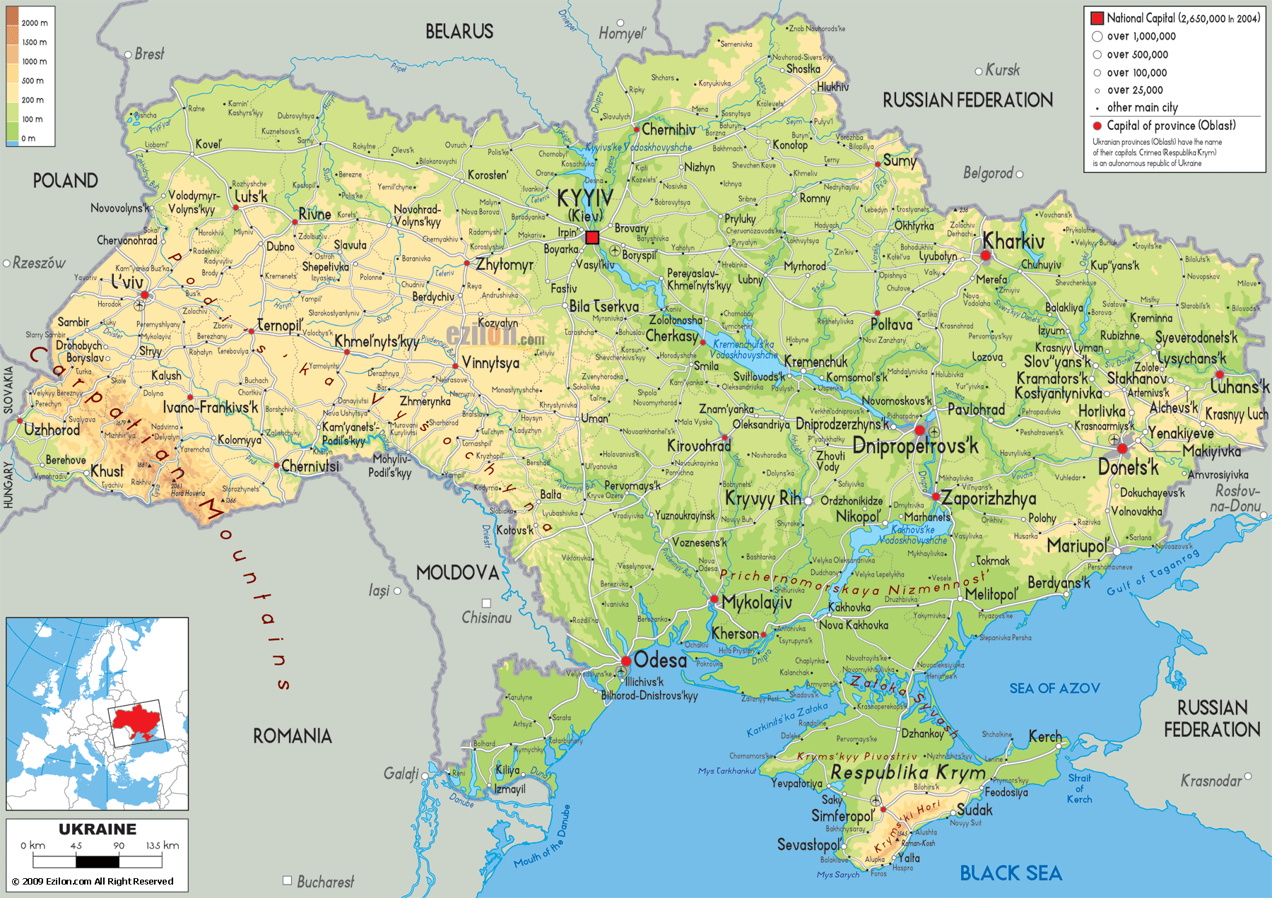
Description: The physical map of Ukraine showing major geographical features like elevations, mountain ranges, seas, lakes, plateaus, peninsulas, rivers, plains, landforms and other topographic features.
 Detailed Physical map of Ukraine showing steppe plains, the carpathian mountains and the dnieper river, elevations and other topographic features. Ukraine is a vast and diverse country in Eastern Europe, stretching from the Carpathian Mountains in the west to the Donets Ridge in the east, and from the forested northern plains to the sunlit Black Sea and Sea of Azov coasts in the south. Looking at the physical map of Ukraine before you, it’s clear that this country’s landscape is a geographical mosaic, rich in plains, rolling hills, fertile river valleys, rugged highlands, and extensive coastlines. This guide will take you on a province-by-province journey, narrating every detail visible on the map, while seamlessly explaining Ukraine geography.
Ukraine is the largest country in Europe by area with the total area of 603,500 square km A detailed layout of steppe, occident, heights and basins is shown in its physical map. A large part of country’s territory forms part of the east European plain which makes it possessor of low elevations in large area.
Ukraine shares land borders with:
Poland to the northwest
Slovakia and Hungary to the west
Romania and Moldova to the southwest
Belarus to the north
Russia to the northeast and east
The sea of Azov and the black sea form the southern boundary which you can see at the lower end of the map.
If you study the legend on the left of the map, you’ll notice different colors representing elevation:
Green shades mark lowland plains (0–200 m)
Yellow and orange shades mark uplands and moderate heights (200–500 m)
Brown shades indicate high mountain ranges, especially in the Carpathians and the Crimean Mountains
The most prominent mountainous region in Ukraine lies in the far west. On the map, you’ll see deep brown ridges marking the Carpathian Mountains in Zakarpattia Oblast and part of Ivano-Frankivsk Oblast. This is the highest range in the country, home to Mount Hoverla (2,061 m), Ukraine’s tallest peak.
In the far southwest, near Uzhhorod and Mukachevo, the map reveals valleys that cut through the mountains like rivers, all heading for Hungary, Slovakia, and Romania. This area has lots of forested hills and alpine meadows, which is great for hiking.
Moving east along the Carpathian crest, the Chornohora Range stands out with its jagged brown lines. This ridge is the heart of Ukraine’s alpine zone.
As we move north and slightly east from the Carpathians, the elevation decreases into rolling highlands. The Podolian Upland, covering parts of Ternopil, Khmelnytskyi, and Vinnytsia oblasts, is visible as yellowish zones on the map. North of it lies the Volhynian Upland in Volyn and Rivne oblasts.
These areas feature deep river valleys, especially along the Southern Bug River. The uplands are fertile and densely cultivated, forming one of Ukraine’s main agricultural zones.
The top part of the map, particularly along the borders with Belarus and Poland, shows vast green expanses - this is the Polissya Lowland. The region includes swamps, peat bogs, and mixed forests. It occupies Volyn, Rivne, Zhytomyr, Kyiv and Chernihiv oblasts.
On the map, you’ll see the Pripyat River meandering through the north, feeding into the Dnieper. Numerous tributaries weave across the lowlands, creating a watery landscape.
One of the most striking features on the physical map is the Dnieper River (Dnipro), flowing southward from Belarus through the heart of Ukraine to the Black Sea. It divides the country into Right-Bank Ukraine (west of the river) and Left-Bank Ukraine (east of the river).
If you trace the river on the map, you’ll spot large blue stretches — these are reservoirs created by hydroelectric dams, such as the Kyiv Reservoir and Kakhovka Reservoir.
Between the Dnieper and Southern Bug Rivers lies the Dnieper Upland, marked in light yellow. The region comprising Cherkasy, Kirovohrad and the north-western part of Poltava oblast is a gentle rolling plateau of black soil.
In the far east, near Donetsk and Luhansk oblasts, the elevation rises again in the Donets Ridge. This upland region, colored yellow-orange on the map, is rich in minerals and has historically been a central industrial zone. The key minerals and resources mined or found here include:
(a) Coal (especially anthracite and coking coal).
(b) Rock salt
(c) Mercury (quicksilver) ore deposits, such as cinnabar.
(d) Limestone, marl, dolomite, gypsum, and refractory clays.
(e) Rare earth elements: Deposits of rare earth minerals, titanium, lithium, beryllium, manganese, gallium, uranium, and zirconium have been identified, though exploitation varies by mineral and region.
The southern belt of Ukraine, stretching from Odesa to the Sea of Azov, is marked in light green and yellow. A grassland with low-altitude tree cover and high agricultural productivity is called steppe.
Along the southern coastline, you can see broad lowlands where rivers like the Dnister, Southern Bug, and Dnieper empty into the sea. These coastal plains are prime grain-growing areas.
In the south, connected to mainland Ukraine by the narrow Perekop Isthmus, lies the Crimean Peninsula. The northern part is flat steppe, but the southern coast is dominated by the Crimean Mountains, visible on the map as a thin brown strip parallel to the coast.
The highest peak here is Roman-Kosh (1,545 m), located in the main range.
As we move further south along the Dnieper, the map shows the terrain gradually flattening into the Lower Dnieper Lowland, a vast agricultural and irrigation-rich region. The green shading on the map indicates areas under 200 meters in elevation.
Just before reaching the Black Sea, the Dnieper widens into the Kakhovka Reservoir, clearly visible as a broad blue expanse on the map. From here, the river flows through Kherson Oblast, where it branches into multiple channels forming a delta before meeting the sea.
To the west of the Dnieper lies the Southern Bug River, cutting through Mykolaiv and into the Black Sea. Even further west, the Dniester River flows along part of the Moldovan border before curving southeast to meet the sea near Odesa.
The map reveals the Dniester Estuary (Dniester Liman), a long coastal lagoon separated from the Black Sea by a narrow sandbar. This is a unique physical feature that draws attention for both ecological and economic reasons.
Looking at the southern edge of the map, the coastline stretches from the Danube Delta in the west to the Kerch Peninsula in the east. The low-lying coastal plains are shown in bright green, indicating minimal elevation.
In the far southwest corner, the map shows the Danube River splitting into multiple channels as it enters the Black Sea. This wetland area is one of Europe’s most important biodiversity hotspots.
The coastline along Odesa is characterized by sandy beaches, low cliffs, and limans - coastal lagoons separated from the sea by narrow spits of land.
Moving east along the map, the coastline changes character. The Sea of Azov, located between southern Ukraine and southwestern Russia, is much shallower than the Black Sea. On the map, its coastline is dotted with sandspits and small peninsulas.
The most noteworthy feature here is the Arabat Spit, a long thin piece of land which extends over 100 km along the western shore of the Sea of Azov. The landform separates the sea and the Syvash, a large shallow marshy area that tinges pink due to saline algae.
The Crimean Peninsula stands out on the map with its varied terrain. The steppes are found in the northern half whilst the southern edge is bordered by the Crimean Mountains.
These mountains form three parallel ridges:
Main Range - highest, with Roman-Kosh Peak (1,545 m)
Middle Range
Outer Range
The southern slopes drop steeply toward the Black Sea, creating a warm coastal strip famous for vineyards, orchards, and resorts.
Along the map’s southernmost edge, you can see cities like Yalta and Sevastopol nestled between the mountains and the sea, forming picturesque bays.
East of the Dnieper lies the Dnieper Lowland, extending into the Donets Basin (Donbas region). This area is marked on the map with light green and pale yellow colors, showing low hills and flatlands.
Yellow-orange shades on map depict Donets Ridge towards Luhansk and Donetsk oblasts with elevation going up to 367 metres. The Seversky Donets and other river valleys dissect the region.
Ukraine’s hydrology is one of its most defining physical features, and the map provides a clear view of its river network.
Dnieper (Dnipro) flows from north to south into the Black Sea
Dniester - southwestern Ukraine
Southern Bug - central-southern Ukraine
Seversky Donets - eastern Ukraine
Tysa – western Ukraine, in Zakarpattia
Prut – southwestern border with Romania
By observing the color gradients on the physical map:
Green (0–200 m) - Coastal plains, river valleys, lowlands
Yellow (200–500 m) - Uplands like the Podolian Upland
Orange/Brown (>500 m) - Carpathian Mountains, Crimean Mountains
Although the map doesn’t show climate, the landform of Ukraine influence climatic condition:
Northwest and North - Humid continental with forests
Central and South - Steppe climate, hot summers
Southern Coast - Warm Mediterranean-like climate in Crimea
This physical map is an important study resource for geography students, helping them to understand the relationship between the landforms, rivers and settlement patterns. Travelers learn where to find mountain trekking in the Carpathians, beach resorts in Crimea, and wetland birdwatching in the Danube Delta.
Ukraine natural landscape is as rich as diverse. A few words can describe that, “from the snow-capped peaks of the Carpathians to the expansive steppe to the south, from the fertile river valleys to the warm shores of the Black Sea”.
This map is more than a tool for navigation; it is a visual representation of the nature features in the area that have determined settlement, agriculture and travel.

Political Map of Ukraine
Political map and map image of Ukraine.

Road Map of Ukraine
Road map and map image of Ukraine.

Regional Directory of United States of America
Information and guide about United States of America and websites with American topics.

Regional Directory of Europe
Information and guide about Europe and websites with European topics.

Regional Directory of Australia
Information and guide about Australia and websites with Australian topics.