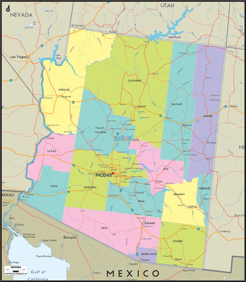
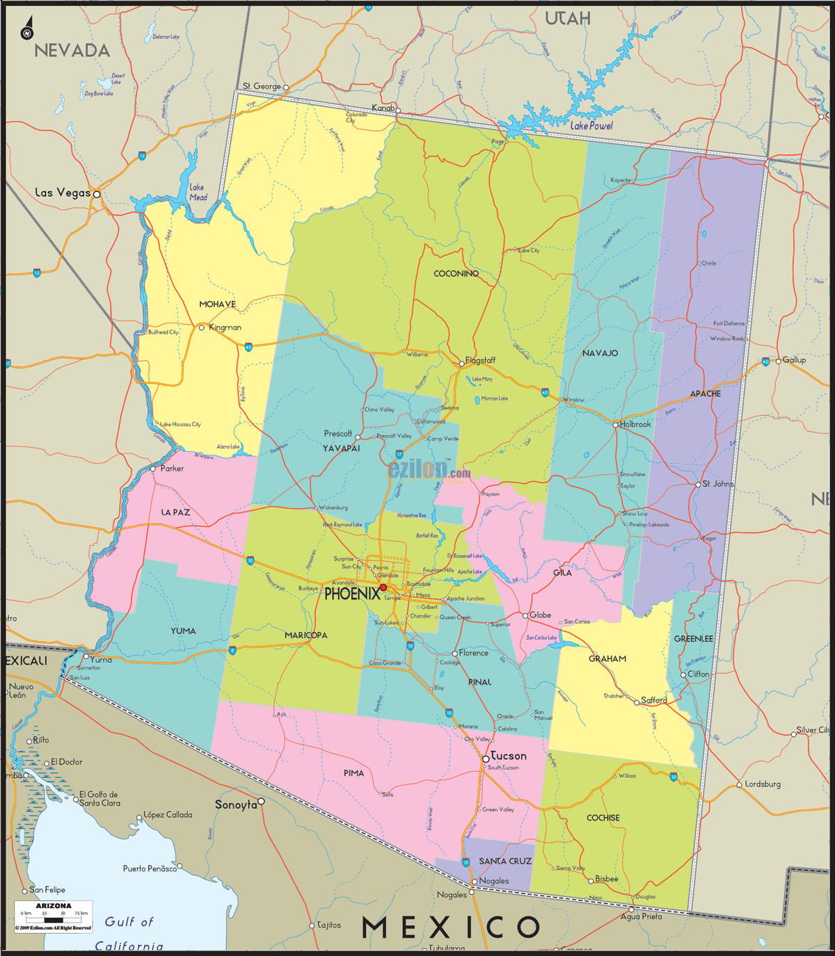
Description: Detailed large map of Arizona State, USA showing cities, towns, county formations, roads highway, US highways and State routes.
 Map of Arizona (USA). Arizona map with cities, counties, and towns. Use this detailed map to understand Arizona's full county grid, every administrative capital (county seat), the major cities and towns, bordering states and waters, and a few highway cues for orientation only. The ideal map style for residents, travelers, and geography students wanting clarity without road clutter. A large state like Arizona - over 113,000 square miles - cannot fit on one page. So this map uses a county grid instead of a maze of highway lines.
Fifteen counties are etched in their own color on the map that carries almost everything useful: where a city is located, which government takes care of it, and how far it is to the adjacent city. You can easily find Phoenix, Tucson, Flagstaff, and even the smaller county seats within seconds, whether you are trying to discover which city is what, where to find a county line, or just wanting to get a feel of the state as a whole.
Borders and waters at a glance: California and Nevada sit across the Colorado River to the west, Utah closes off the north, New Mexico runs the length of the east side, and the Mexican state of Sonora borders Arizona along its entire southern edge. The river is really the thing to remember here. It flows down from Lake Powell, through Lake Mead, Lake Mohave, and Lake Havasu, then past Parker and Yuma before crossing into Mexico. Almost every western county line in Arizona follows that same blue thread.
Orientation of interstates: Five interstates run through the state. The I-10 Highway cuts diagonally through the low desert of California, Phoenix, and Tucson. North of Phoenix is the Flagstaff I-17. Interstate 19 (I-19) is the highway connecting Tucson to Nogales on the border. The I-40 runs east to west through the northern county, and I-8 extends from Yuma to Phoenix Basin. Observe that the most searched municipalities by people, which are Phoenix, Tucson, Flagstaff, Yuma, and Nogales - all sit where these roads cross the county. It is no accident, and that is precisely why they function as beacons.
Start in the northwest corner, where Arizona meets Nevada. Mohave County is the big one up here, and its seat, Kingman, grew up right where old Route 66 crosses I-40 on the way to Hoover Dam and Las Vegas. Follow the county south along the river and you pass Bullhead City and Lake Havasu City, with Lake Mead and Lake Mohave filling the canyons behind the dam. La Paz County comes next, Arizona's newest, split off from Yuma County back in 1983. Its seat, Parker, sits right on the Colorado, and Quartzsite, a little further south, wakes up every winter for one of the largest gem and mineral shows in the country. Keep following the river and you reach Yuma County, where the city and the county share a name. Yuma sits at the exact spot where the Colorado meets the Gila, and its winter lettuce fields feed a good part of the country from November through March.
The desert starts to rise when you go inland from the river. Prescott is the county seat of Yavapai County and the geologic Transition Zone, the in-between country separating low desert from high plateau. For more than a century, residents of Phoenix have been relocating to Prescott for its quaint, pine-covered appeal.
You can reach the city of Chino Valley, Prescott Valley, Camp Verde, and the red rocks of Sedona. Your directions will take you into the expansive Coconino County, the largest county in Arizona. It has a hefty size of about 18,700 square miles. Flagstaff is the county seat of Coconino County and sits at 7,000 feet on I-40, which is cool enough for real winters. Due to its proximity to the Grand Canyon, Lake Powell, and Page, tourism almost runs the local economy like the university.
Coconino County to the East lies in Navajo County, which runs on I-40 through the town of Holbrook with towns Winslow and Show Low. Head east into Apache County, home of St. Johns, and you'll find yourself in the far corner of the state, bordering Utah and New Mexico. Most of this county lies within the Navajo Nation, and towns thin out quickly; the names on the map don't seem to get much other than Springerville and Eagar near the White Mountains. This area is the most tranquil in the state, and the map illustrates this: great lengths of open color separating one small town from another.
Maricopa County has pretty much all of Arizona's population, not even close. The metropolitan area of Phoenix, which is also its seat and capital, lies in a ring formed by Mesa, Chandler, Gilbert, Glendale, Scottsdale, Tempe, Peoria, and Surprise. A tight grid of freeways links together cities that, from the ground, appear to meld into one another. Southeast of all that growth, Pinal County, seat Florence, runs along the Gila River through Casa Grande and Coolidge, the farmland belt between Phoenix and Tucson. East of Gila County, Globe is another copper-mining community. Routes get tangled here. Phoenix, San Carlos, and the White Mountains all meet in Globe. Pine forest replaces desert almost as soon as you cross the county line.
To the south of Pinal, across the Santa Cruz River, lies Tucson and Pima County, Arizona's second most populous, where mountain ranges on both sides force I-10 and I-19 through town, rather than a direct route south. Santa Cruz County is also located on the border. However, it is the smallest county in this state by area. Nogales is the county seat of Santa Cruz County, which must handle some of the heaviest cross-border traffic anywhere along the US-Mexico border.
Cochise County is east of Santa Cruz and east of here on the way to Willcox along I-10. Towns like Bisbee, Tombstone, and Sierra Vista trade heavily on their Old West and mining history. Situated north of Cochise, Graham County runs along the Gila River to reach its seat, Safford. Also, the small Greenlee County, the least populated county in the state, centers on Clifton and the copper mines around Morenci.
Almost all of the work is done by three rivers. The Colorado River runs along the full length of the western edge from Lake Powell to Yuma. The Gila River flows across the south-central part of the state from the New Mexico line through Safford and Florence and into the Colorado at Yuma. The Gila River receives the Salt River from the Phoenix basin, which is the source of Roosevelt Lake. If you master these three, you make easy placement of almost any county on this map.
Every one of Arizona's 15 counties and its seat, in alphabetical order: Apache–St. Johns; Cochise–Bisbee; Coconino–Flagstaff; Gila–Globe; Graham–Safford; Greenlee–Clifton; La Paz–Parker; Maricopa–Phoenix; Mohave–Kingman; Navajo–Holbrook; Pima–Tucson; Pinal–Florence; Santa Cruz–Nogales; Yavapai–Prescott; Yuma–Yuma. This full county-and-seat index matches every label you will find on the map above.
Arizona's western boundaries are California and Nevada; Utah borders the north, New Mexico the north-east, and Mexico (Sonora) the south-east. The map is made of color blocks for the 15 counties and stitched together by I-10, I-17, I-19, I-40, and I-8. Phoenix is the capital; Coconino County is the largest county by area. Santa Cruz County covers a land area of about 1,238 square miles. Maricopa County, the most populous county, is home to Phoenix and has around 4,673,096 residents. Greenlee County is the least populated county in Arizona.
The oldest counties in Arizona, Mohave, Pima, Yavapai, and Yuma, were established in 1864. La Paz County is Arizona's newest county, created in 1983. The total area of the state is about 113,990 square miles, making it the sixth-largest state in the country. In northern Arizona, the Colorado Plateau's Grand Canyon and Flagstaff exist; through the transition zone, Prescott and Globe show impact; and south, in the Sonoran Desert, rise Phoenix and Yuma.
Roads in Arizona are often rebuilt, renumbered, and rerouted more than you think. County lines do not. The most recent change to the county system was in 1983, when La Paz broke away from Yuma. Everything apart from this change has not been modified since Arizona became a territory in 1864. This is the actual reason that this map of counties in Arizona leads off with blocks shaded various colors instead of a dense grid of highways.
The county line isn't the primary highway or line of commerce. Rather, it decides which courthouse oversees your paperwork, which school district your address falls under, and who sets your property tax rate, none of which you'll ever find out from a road atlas. Minimizing information does not keep the roads light. Whether you're trying to find a county seat, discover which side of a river a town sits on, or just get your bearings before a longer drive, keeping the page readable.
The economic narrative of Arizona's cities comes mostly from its largest. Massive cities such as Phoenix are among the largest in the US. Similarly, other cities lie in Arizona. The cities listed above are major cities in AZ, located mainly in Maricopa County. In recent years, Phoenix and its surrounding suburbs have developed a genuine semiconductor and advanced manufacturing hub, as new chip factories arrive in Chandler and north Phoenix, and older aerospace and defense work around Mesa and Tucson.
Mining is also still active or historically significant for copper in Pinal, Gila, Graham, and Greenlee counties. Yuma County is the source of much of the winter lettuce and produce you eat. This is because their fields are irrigated, yielding high-quality crops. Meanwhile, the Grand Canyon, Sedona, and the lakes of the Colorado River generate plenty of tourism, which creates jobs in Coconino, Yavapai, and Mohave counties.
The culture of Arizona is as closely mapped to its counties as its economy is. The country's Largest Reservation is the Navajo Nation, located in the counties of Apache, Navajo, and Coconino, with the Hopi Reservation located inside the Navajo Nation in Navajo County. Cochise County still lives in the Old West; both Tombstone and Bisbee rely on a mining-plus-gunfight-era legacy.
The towns on Route 66 - Kingman, Williams, Flagstaff, Winslow, and Holbrook are located across the northern counties and ensure a consistent traffic of road-trip tourists through Mohave, Coconino, and Navajo counties. Sedona is divided between Yavapai County and Coconino County.
People have become enamored with the red rock scenery as well as the decades-long arts-and-crafts scene. Higher education is heavy on the map too, as Arizona State University in Tempe, the University of Arizona in Tucson, and Northern Arizona University in Flagstaff each shape their region's economy almost exactly as they shape their identity.
Humphreys Peak, in the San Francisco Peaks north of Flagstaff, and the Colorado, Gila, and Salt rivers are the quickest landmarks for finding a county on this map. For elevation, terrain, watersheds, and land cover, see our Physical Map of Arizona.
The south and west of the state run hot desert almost year-round, while the Colorado Plateau up north stays noticeably cooler, cool enough for real winters in Flagstaff. See our Physical Map of Arizona for the full seasonal breakdown.
Traveling north to south usually involves taking I-17 between Phoenix and Flagstaff or I-19 between Tucson and Nogales. Arizona contains two corridors as revealed by the east-west divisions of industrial and commercial development. The southern corridor is the primary one from California to a point on the border with Mexico. It passes through a state's urbanized centers of an important scale.
It is served by I-10. The other is a more important corridor along I-40, which connects Kingman to the quarter link with New Mexico. I-8 runs between Yuma and the Phoenix basin in the southwestern corner. Arizona's ZIP codes do not follow county lines - one ZIP can span two counties, and other interesting facts are worth noting. Whenever uncertain, refer to the map or index for the name of the county, and do not guess from a ZIP prefix.
Arizona has 15 counties and the map shows every one with a colored block and county seat.
County boundaries, county seats, and neighboring states, with only light road references for orientation.
Phoenix, in Maricopa County near the center of the state.
Maricopa County.
Pima County, in southern Arizona.
In Coconino County, Arizona's largest county by land area.
In Yavapai County, connected by road to Chino Valley, Prescott Valley, and Camp Verde.
In Yuma County, near the meeting point of the Colorado and Gila rivers close to the Mexico border.
In Mohave County, where Interstate 40 meets the route toward Nevada.
Nogales is in Santa Cruz County; follow Interstate 19 south from Tucson.
Both in Navajo County along Interstate 40.
In Apache County, near the New Mexico border in northeastern Arizona.
In Gila County, at the junction of routes from Phoenix, San Carlos, and the White Mountains.
In Graham County, near the Gila River in southeastern Arizona.
In Greenlee County, Arizona's least populous county, near the Morenci mining district.
In Pinal County, along the Gila River valley between Phoenix and Tucson.
In La Paz County, along the Colorado River, Arizona's newest county, established in 1983.
Mohave, La Paz, and Yuma, all along the Colorado River.
Mohave County, near Kingman and the Hoover Dam corridor.
Mohave and Coconino counties along Arizona's northern edge.
Apache, Greenlee, Graham, and Cochise counties.
Yuma, Pima, Santa Cruz, and Cochise counties along the Sonora line.
Interstate 10 runs from California through Phoenix and Tucson to New Mexico, Interstate 40 crosses northern Arizona, and Interstate 8 links Yuma with the Phoenix region.
It runs north from Phoenix to Flagstaff, linking the Sonoran Desert with the Colorado Plateau.
Interstate 10 through Maricopa, Pinal, and Pima counties.
I-10, I-17, I-19, I-40, and I-8 only as soft reference lines.
Yes. Roosevelt Lake and San Carlos Lake in central and southeastern Arizona, plus Lake Powell on the Utah line.
Coconino County, at about 18,661 square miles.
Santa Cruz County, at about 1,238 square miles.
Maricopa County, with roughly 4,673,096 residents, home to Phoenix.
Greenlee County, with roughly 9,410 residents.
Phoenix, followed by Tucson and Mesa.
Mohave, Pima, Yavapai, and Yuma counties, all created in 1864. La Paz County is the newest, established in 1983.
No. County lines and ZIP code boundaries do not always match, so use the county boundaries and seats shown here instead.
No. Printing or copying our maps from the site is not permitted.

Physical Map of Arizona
Physical map and map image of Arizona.

Deserts and Arid Regions of Arizona
Geographical map showing deserts and arid regions of Arizona.

Regional Directory of United States of America
Information and guide about United States of America and websites with American topics.

Regional Directory of Europe
Information and guide about Europe and websites with European topics.

Regional Directory of Australia
Information and guide about Australia and websites with Australian topics.
