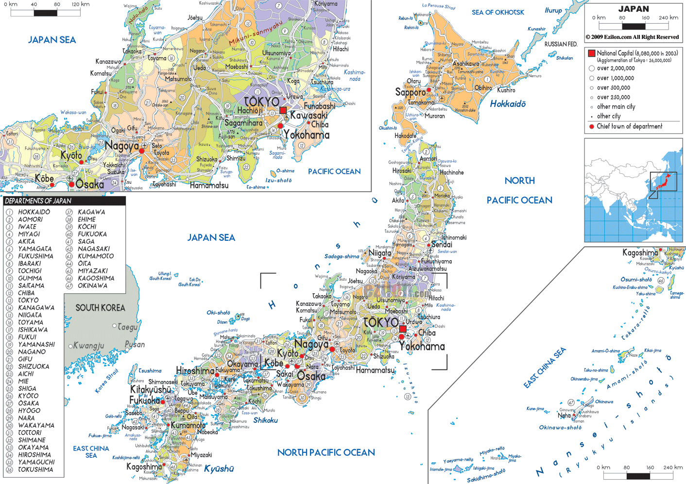
Description: Detailed large political map of Japan showing names of capital city, towns, states, provinces and boundaries with neighbouring countries.

Map of Japan, Japan map with cities, towns, and prefectures. The Japan map is a detailed map of the country, from northern Hokkaido to southern Okinawa. It divides Japan into its 47 prefectures and shows each major city, secondary town, and local administrative center.
The map is a pretty good way to see how Japan is organized politically and where people live because it emphasizes the borders of prefectures, city names, sea names, and neighboring countries rather than physical relief.
In eastern central Honshu, the map of Japan's cities shows Tokyo as the national capital and the largest urban area. A fat label on Tokyo makes it clear that the large urban sprawl on this map is actually part of the Yokohama-Kawasaki-Saitama-Chiba cluster of cities, all major cities in the Kanto region.
The Tokyo Metropolis, Kanagawa, Saitama, Chiba, Ibaraki, Tochigi, and Gunma prefectures are shaded individually; the boundaries and names of their respective capitals are also clearly visible, allowing the reader to see where administrative lines cross.
The area shown on this Japan map of cities and regions gives you an idea of how densely packed Kanto is. Many cities with millions of residents sit side by side along Tokyo Bay and inland corridors. The cluster of labels helps residents and travelers understand which route to take for central Tokyo, Yokohama's port, Saitama's fanned-out inland suburbs, and Chiba's more coastal communities. Geography students can use this section to study megalopolises and urban corridors in Japan.
In the northern portion of the map is Hokkaido, a region and prefecture that occupies Japan's second-largest island. The map of Japan with towns shows Sapporo as the prefecture's capital and a major city. As such, you can see it marked with a large circle.
Meanwhile, other towns such as Asahikawa, Hakodate, and Kushiro appear as small dots on the map of Japan, with towns comprising the country. The sea and country labels provide maritime users a strong sense of Japan's northern maritime boundary and Hokkaido's proximity to Russia and the Sea of Okhotsk.
To the south of Hokkaido, the Tohoku, or Northeast, region of Japan is located in the northern half of Honshu and includes the prefectures of Aomori, Iwate, Miyagi, Akita, Yamagata, and Fukushima. Regional centers include the cities of Sendai, Aomori, Morioka, Akita, and Yamagata, as well as small coastal and inland towns.
The Tohoku region is less populated, but it still has cities. As shown on the map of Japan, towns and cities are present here and are essential for fishing, agriculture, and the industrial and processing lifelines.
Chubu refers to the central region of Japan. In Japanese, chū means central, and bu means area or province. In the Japan map, Chubu includes the prefectures of Nagano, Kanagawa, Yamanashi, Fukui, Aichi, Gifu, and Shizuoka. Important prefectures include Niigata, Nagano, Yamanashi, Shizuoka, Toyama, Ishikawa, Fukui, Gifu, Aichi, and Mie. Their capital is labeled, and boundaries are drawn. Nagoya, located in Aichi Prefecture and home to Nagoya Castle, is Japan's largest city.
Between the larger and smaller places, which might be categorized as hamlets, are shown medium circles of Shizuoka, Hamamatsu, Kanazawa, and Toyama above the first larger cities. The region shows the main rail and road corridor linking Tokyo, Nagoya, and Osaka, as well as alternative options along the northern coast through Niigata and Kanazawa, for those who subsequently visit Japan's cities.
On the West of Japan map above, you will see the Kansai region, a dense cluster of prefectures and cities along Osaka Bay. The borders of prefectures Osaka, Kyoto, Hyogo, Nara, Shiga, and Wakayama are shown with adjacent colors. The major cities Osaka, Kyoto, and Kobe are shown in solid text and connected by the distances shown between letters to signify their closer relationship.
Second in Hokkaido, detours will take you to coastal towns such as Nara, Otsu, and Wakayama, which are shown as smaller circles beyond the main urban area in Kansai. This area of the map of Japan with regions shows a classic multi-nuclei metropolitan area, which makes it noteworthy for geography students. For tourists, the map shows that it is easy to travel between Kyoto's cultural centers and Osaka and Kobe's urban areas.
Located in western Honshu, the Chugoku region is bordered to the east by the main island of Japan. It includes cities like Akita, Matsue, Hiroshima, Okayama, and Takamatsu, to name a few. Counties in this area include Okayama, Hiroshima, Yamaguchi, Tottori, and Shimane Prefectures. Their capital cities, Okayama, Hiroshima, and Yamaguchi, are all marked with a circle and a label on the map above. The city of Hiroshima, located on the Inland Sea, is an important city and a historical place.
The map of Japan shows that the island of Shikoku lies south of the Seto Inland Sea. This island region includes Kagawa, Tokushima, Ehime, and Kochi prefectures, all of which appear on the map of Japan, along with towns and villages. The smaller port towns along the coast are regional capitals, including Takamatsu, Matsuyama, Tokushima, and Kochi. The regions of Chugoku and Shikoku give a good idea of how western and southwestern Japan are laid out around the Inland Sea, where cities are joined by ferries and bridges.
The Kyushu region and Okinawa Prefecture in southwestern Japan are visible on the map of Japan. The Kyushu region incorporates the prefectures Fukuoka, Saga, Nagasaki, Kumamoto, Oita, Miyazaki, and Kagoshima.
Six important urban centers - Fukuoka, Kitakyūshū, Nagasaki, Kumamoto, and Kagoshima – all of which are labeled, which indicates Kyushu's position as an important area for industry and culture near South Korea and China.
On the Japan map, these islands are identifiable for the most part as a chain of small islands extending into the East China Sea. Farther south, you can find these islands and towns of Okinawa Prefecture and the Ryukyu Islands. The main island of Okinawa is home to the capital, Naha, while smaller islands dot the rest of the settlements, showing where people live in these subtropical municipalities in the southern archipelago.
Think of the journey starting in northern Japan and heading south. As you depart from Sapporo, located in Hokkaido, detours will take you to coastal towns like Atoru, Asahikawa, and Hakodate, and thereafter cross the strait to Aomori and the Tohoku region. Tracing using the map along the Pacific coast of Honshu through the cities of Sendai, Fukushima, Mito, Tokyo, Yokohama, and Nagoya, which are the main transport corridors of Japan.
The line of cities on the map of Japan turns west, then heads south through Fukuoka. The Kumamoto-Nagasaki-Kagoshima-Naha (Okinawa) route branches off from there toward the towns and cities shown on the map. Drawing reveals that Japan's urban design, from north to south, reflects both Japan's archipelagic nature and its urban design.
Japan's map clearly shows the oceans, neighboring countries, and Japan's cities and regions. To the east of Japan, the Sea of Japan lies to the west of South Korea and Russia. To the east is the North Pacific Ocean. To the south are the East China Sea and the maritime borders with China and Taiwan. These labels reiterate how Japan is an island nation, lacking land borders. Nonetheless, Japan is surrounded by busy shipping lanes and has close neighbors, which matter for trade, travel, and security.
We share this context as travelers planning a trip, using a map of Japan showing cities and towns, as well as ferry links and air routes to nearby countries. The same information benefits students in lessons on East Asian geopolitics and regional geography.
The town's legend for the political Map of Japan uses symbol sizes to clearly express an urban hierarchy. The megacity category includes cities such as Tokyo and Osaka, both million-plus and globally powerful. The next major designated cities, such as Yokohama, Nagoya, Sapporo, Fukuoka, Kobe, and Kyoto, have large circles and names in bold. Beneath them lie the prefectural capitals and core cities, represented by somewhat smaller symbols, and then comes the wide array of smaller towns that furnish local amenities and sustain the national settlement pattern.
This hierarchy is useful for readers who need to know where the most significant transport hubs and economic centers are located when consulting a Japan map with cities, and it also helps students understand how Japan's urban system is structured from the national to the local scale.
The map of Japan with cities and towns is quite useful because it combines prefectures, regional areas, cities, towns, the sea, and a neighboring state. Residents will be able to identify their prefecture, the city that serves as its capital, and whether their town is in Hokkaido, Kanto, Kansai, or Kyushu. Tourists will value the Japan map with cities and regions, which will enable them to plan itineraries through Tokyo, Kyoto, Osaka, Hiroshima, Fukuoka, and Okinawa. It will also show them intermediate towns where they might stop.
For geography students, the map of Japan with regions is almost a complete teaching tool, showing the 47 prefectures, the eight traditional regions, key sea areas, and major urban centers in a single view. Since this political map omits physical features, learners can focus on administrative divisions, population distribution, and transport corridors before layering in other themes such as climate, landforms, or historical sites in their studies.
Japan is located in East Asia between the Pacific Ocean and the Sea of Japan.
Japan is made up mainly of Hokkaido, Honshu, Shikoku, Kyushu, and Okinawa islands.
The political map divides Japan into 47 prefectures across eight traditional regions.
Tokyo is shown as the national capital and largest metropolitan area in Japan.
Major cities shown include Tokyo, Yokohama, Osaka, Kyoto, Kobe, Nagoya, Sapporo, Hiroshima, and Fukuoka.
The map shows Hokkaido, Tohoku, Kanto, Chubu, Kansai, Chugoku, Shikoku, and Kyushu with Okinawa.
Tokyo is located in the Kanto region on eastern Honshu beside Tokyo Bay.
Prefectures surrounding Tokyo include Kanagawa, Saitama, Chiba, Ibaraki, Tochigi, and Gunma.
The corridor includes Tokyo, Yokohama, Kawasaki, Chiba, and Saitama.
Yokohama is located south of Tokyo in Kanagawa Prefecture along Tokyo Bay.
The Kanto region shows Japan's densest urban corridor with major cities connected by transport routes.
Hokkaido is the northernmost main island of Japan near the Sea of Okhotsk and Russia.
Cities shown in Hokkaido include Sapporo, Hakodate, Asahikawa, and Kushiro.
Tohoku includes Aomori, Iwate, Miyagi, Akita, Yamagata, and Fukushima prefectures.
Cities shown include Sendai, Aomori, Morioka, Akita, Fukushima, and Yamagata.
Chubu prefectures shown include Niigata, Nagano, Yamanashi, Toyama, Ishikawa, Fukui, Gifu, Aichi, and Shizuoka.
Nagoya is located in Aichi Prefecture in central Honshu.
Cities around Nagoya include Hamamatsu, Shizuoka, Toyama, and Kanazawa.
The map shows a major urban and transport corridor running through central Honshu between Tokyo, Nagoya, and Osaka.
Kansai prefectures shown include Osaka, Kyoto, Hyogo, Nara, Shiga, and Wakayama.
Major Kansai cities shown include Osaka, Kyoto, Kobe, Nara, and Otsu.
Osaka is located along Osaka Bay in western Honshu.
Kyoto is shown as a major historic and cultural city connected closely to Osaka and Kobe.
Chugoku includes Okayama, Hiroshima, Yamaguchi, Tottori, and Shimane prefectures.
Cities shown include Hiroshima, Okayama, Matsue, Takamatsu, Matsuyama, Tokushima, and Kochi.
Kyushu prefectures shown include Fukuoka, Saga, Nagasaki, Kumamoto, Oita, Miyazaki, and Kagoshima.
Major cities shown include Fukuoka, Kitakyushu, Nagasaki, Kumamoto, Kagoshima, and Naha.
The map shows the Sea of Japan, Pacific Ocean, East China Sea, Sea of Okhotsk, and nearby Russia, China, North Korea, and South Korea.
Yes, the map helps travelers and students study prefectures, urban corridors, transport routes, and regional geography.
No. Printing or copying maps from this site is not permitted.

Physical Map of Japan
Physical map and map image of Japan.

Road Map of Japan
Road map and map image of Japan.

Regional Directory of United States of America
Information and guide about United States of America and websites with American topics.

Regional Directory of Europe
Information and guide about Europe and websites with European topics.

Regional Directory of Australia
Information and guide about Australia and websites with Australian topics.