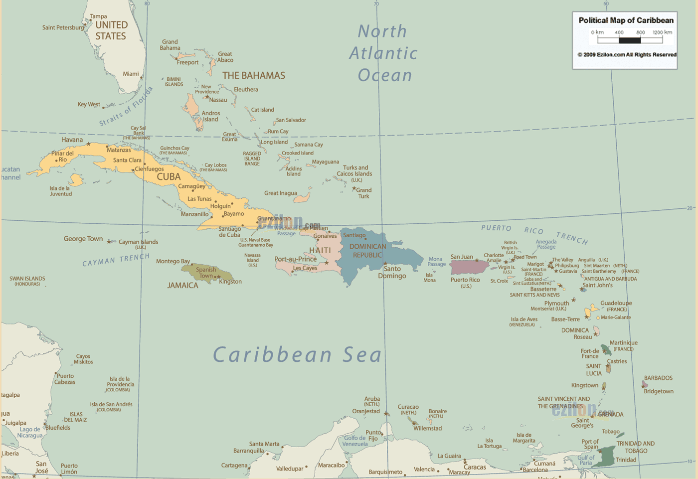

Description: Detailed Map of Caribbean showing all countries maps, names of capital cities, towns, states, provinces and boundaries of neighbouring countries.
Introduction: Venture into the heart of the Caribbean, a glorious mosaic of sun-kissed islands, vibrant cultures, and pulsating rhythms. Our meticulously designed Map of the Caribbean goes beyond delineating territories - it's a melodic symphony of tales from the times of buccaneers, colonial legacies, and the irrefutable spirit of Carnaval. As you journey through this map, you'll traverse stories of ancient Taino civilizations, tales of piracy, the enthusiasm of independence movements, and the spicy zest of Creole cuisines.
This map, a labor of passion, illuminates the Caribbean in all its splendor, from the bustling boardwalks of Bridgetown, Barbados, to the historic remnants of Havana, Cuba; from the reggae beats of Kingston, Jamaica, to the colorful Dutch architecture of Willemstad, Curaçao. With its melange of languages, flavors, and traditions, the Caribbean beckons for an immersive odyssey.
Our map showcases the Caribbean in all its multifaceted beauty. From cities steeped in history like San Juan, Puerto Rico, and Port-au-Prince, Haiti, to the serene beaches of Nassau, Bahamas, or the quaint charm of towns like Speightstown, Barbados, and Gustavia, Saint Barthélemy.
From the Carnival celebrations in Port of Spain, Trinidad and Tobago, to the French allure of Fort-de-France, Martinique; from the bustling markets of Castries, Saint Lucia, to the UNESCO-recognized forts of St. George's, Grenada, our map encapsulates the vibrant spirit of the Caribbean. With its unique topography, every island is meticulously represented, from the waterfalls of Ocho Rios, Jamaica, to the underwater marvels of George Town, Cayman Islands.
The Caribbean is between the Americas and has a wide range of geography, just like its culture. Bordered by the vast Atlantic Ocean and the deep blue Caribbean Sea, ports like Roseau, Dominica Basseterre, St. Kitts, and Nevis mirror their maritime legacy. The region’s landscape encompasses more than white-sand beaches, lush rainforests, active volcanoes, coral reefs, and mangrove swamps.
Majestic peaks like La Soufrière in Saint Vincent serve as sentinels overlooking centuries of history, while the bioluminescent bays of Vieques, Puerto Rico, exemplify nature's magic.
The Caribbean Islands consist of a collection of stunning islands in the Caribbean Sea with apparent water. You can find these islands in the western hemisphere. The list encompasses a variety of islands, such as the Bahamas, Cuba, Guadeloupe, Jamaica, and the Virgin Islands.
The Caribbean is a paradise retreat for all those who enjoy water sports such as sailing and scuba diving, as well as just lazing on the pristine white sandy beaches. A diverse range of magnificent plants and animals thrive in these tropical paradises below the water's surface and on the islands.
The Caribbean has a rich historical heritage with relics from the Spanish explorers and settlers and the more common indigenous people of the Caribbean, the Tainos. Although many islands have similar landscapes, these can vary considerably, offering mountain ranges, tropical forests, and splendid coral reefs. The Caribbean is subject to many tropical storms, which can sometimes develop into Atlantic hurricanes, depending on the period of the year; these are more likely to occur from June 1st to November 30th.
Each island, from the salsa rhythms of Cuba to the cricket fields of Antigua and Barbuda, presents a unique narrative. Islands such as the Dominican Republic, with its Spanish zest; Aruba, with its Dutch legacy; Guadeloupe, flaunting its French elegance; and Montserrat, reverberating with Irish folklore, stitch the intricate fabric of the Caribbean.
From the Bob Marley anthems of Jamaica to the Creole tales of Saint Martin, from the cocoa plantations of Grenada to the marine sanctuaries of Turks and Caicos, the Caribbean is a testimony to a fusion of histories, triumphs, and celebrations.
This map doesn't merely mark territories—it dives deep into the Caribbean's cultural, historical, and ecological richness. Follow the footprints of the Arawaks and Caribs, trace the pirate routes, explore the rum distilleries of Barbados, or discover the cigar-making traditions of Cuba. The map is a comprehensive guide, offering insights into festivals, demographics, significant landmarks, and more.
The Caribbean, a kaleidoscope of islands, each humming its unique melody, comprises many nations and territories, from Cuba's sprawling landscapes to the diminutive yet vibrant Saba.
The island nations and territories of the Caribbean are:
Anguilla, Antigua and Barbuda, Aruba, The Bahamas, Barbados, British Virgin Islands, Cayman Islands, Cuba, Curaçao, Dominica, Dominican Republic, Grenada, Guadeloupe, Haiti, Jamaica, Martinique, Montserrat, Puerto Rico, Saint Barthélemy, Saint Kitts and Nevis, Saint Lucia, Saint Martin, Saint Vincent and the Grenadines, Sint Maarten, Trinidad and Tobago, Turks and Caicos Islands, U.S. Virgin Islands.
How to Use this Map on Your Phones:
Use the user-friendly pinch-and-zoom functionality to engage with the lush Caribbean archipelago on your mobile device. Dive deep into this tropical paradise, even amidst your daily engagements, with just a fingertip.
Our Map of the Caribbean is not just cartography; it's an ode to an archipelago that has danced to the tunes of calypso, reggae, and merengue that have risen from colonial pasts to forge independent futures. It invites viewers to wade through tales of island enthusiasm, resilience, and unmatched beauty.
In a world thirsting for connection, understanding the nuances of this island tapestry is pivotal. Set sail through the Caribbean's enthralling narratives and embrace an adventure painted in tropical hues, punctuated with rhythmic beats, and flavored with spices and salt.

Physical Map of Caribbean
Physical map and map image of Caribbean.

Regional Directory of Caribbean
Information and guide about Caribbean and websites with Caribbean topics.

Regional Directory of United States of America
Information and guide about United States of America and websites with American topics.

Regional Directory of Europe
Information and guide about Europe and websites with European topics.

Regional Directory of Australia
Information and guide about Australia and websites with Australian topics.