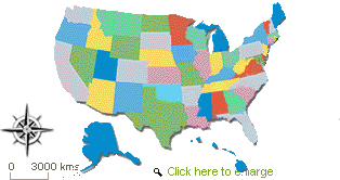
The List of Maps of 50 States of the United States is your A-Z state map directory - a central hub linking to every state's county maps, political maps, physical relief maps, and road-light orientation views. Whether you're a geography student, a teacher building a lesson, a traveler planning a regional road trip, or a researcher confirming a county seat, this collection delivers fast, readable United States maps that keep county borders and labels clear, with interstate highways and U.S. routes shown lightly for bearings rather than turn-by-turn driving.
A complete 50 states map collection saves time and reduces bounce: each state page loads the county-first view you need, with readable state capitals, major cities, regional geography context, and just enough road network detail to orient you quickly. By standardizing the map legend, label sizes, and responsive layout, we ensure that text remains legible across devices, especially on phones, without compromising the precision that scholars and savvy travelers expect.
County maps with clearly drawn county borders, labeled county seats, and a clean state outline for context.
Political maps that emphasize boundaries, jurisdictions, and neighboring states for civics and government studies.
Physical maps highlighting relief, mountain ranges, rivers and lakes, coastlines, and regional landforms to support earth science and travel discovery.
Road-light maps showing interstate highways and U.S. routes as thin, unobtrusive lines, allowing you to place cities without clutter.
We keep highways and corridors visible, but subtle. This state map gives preference to county labels, city names, and state capitals but is also helpful in providing bearings for travel planning and regional movement. This balance helps teachers, students, and casual viewers alike recognize patterns, such as metro areas, rural counties, and border frames - without being visually overwhelmed by detail.
The hub is built for three everyday use cases: quick study, lesson planning, and itinerary building. Each state link opens to a page with a consistent layout, a readable county list, and a map legend tuned for clarity.
Start with the political map to establish the state outline, jurisdictions, and county borders.
Jump to the county map to locate county seats and state capitals before zooming out to neighboring states and regional context.
Use the physical map to overlay knowledge of rivers, lakes, coastal zones, plains, plateaus, and mountain ranges—a proven way to connect human geography with landforms.
Encourage students to identify metro areas and rural counties, then trace probable travel corridors using the interstate grid and major U.S. routes.
Use the road-light view to confirm where major interstate highways intersect county seats and major cities.
Refer to rivers and lakes for recreation planning, then confirm neighboring states and border crossings for multi-state routes.
Cross-check regional geography—coast, mountains, or plains—to estimate realistic travel time and scenic options without a complete driving atlas.
Verify county jurisdiction and county seat for service areas, permits, or sales territories.
Map metro regions and adjacent inland or coastal counties to improve logistics and coverage.
Reference relief maps to anticipate weather exposure, watershed boundaries, and terrain-related accessibility.
Every state page foregrounds the state outline, boundaries, and neighboring states. This frame matters—students and travelers situate the state within the nation and anticipate how borders affect movement, climate, and regional identity.
Counties carry real-world weight: records, courts, services, and local governance. Our county maps prominently feature county borders and county seats, enabling you to identify jurisdictions quickly. This approach clarifies the differences between rural and metropolitan patterns, revealing how state capitals relate to their surrounding counties.
Once you understand the county structure, the interstate grid, and U.S. routes, they help you locate major cities and identify travel corridors. Because roads are drawn lightly, labels stay crisp - useful for lesson slides, trip planning, and classroom handouts (linked, not printed).
The physical map supports any discussion that connects people with landforms: watersheds, coastlines, mountain ranges, valleys, and plateaus. Travelers and teachers can explain why industries cluster along rivers, or why weather varies across regional geography.
Breaking the United States maps into regions deepens learning. Use this primer to frame your viewing and internal linking strategy.
The Northeast combines small state outlines, numerous counties, and complex metro areas. A road-light approach works well here: thin interstate highways and U.S. routes allow densely packed city labels to remain readable. Rivers and coastlines, from tidal estuaries to inland lakes, play a crucial role in shaping urban settlements and trade.
Begin with the political map to grasp the numerous small counties.
Toggle to physical relief for coastal vs inland contrasts.
Utilize county seats to anchor local government in densely populated metro areas.
The South stretches across coastlines, river systems, and rolling plateaus, creating long travel corridors that connect major cities to rural counties. County-first maps help distinguish jurisdictions across large state outlines, while physical maps show why roads align with valleys and watersheds.
Use road-light maps to track interstate spines across state lines.
Consult rivers and lakes for recreation and floodplain awareness.
Compare metro areas with surrounding rural counties for service planning.
The Midwest often features well-defined county borders and state capitals sited centrally or near major hubs. The state map directory makes it easy to compare county seats and trace U.S. routes that interlink agricultural zones, small towns, and large metro regions.
Begin with county maps to understand jurisdiction grids.
Add the interstate highways layer to plan multi-city loops.
Use relief maps to distinguish prairies, lake effects, and river basins.
The West rewards the physical map view: mountain ranges, basins, high plateaus, and dramatic coastlines shape where people live and how they move. Road-light cues preserve readability across vast spaces, while county maps clarify jurisdiction in sparsely populated areas.
Start with relief maps to grasp terrain barriers and passes.
Layer interstates lightly to plan realistic travel times.
Use county seats to find key services in remote counties.
The size and complex coastline of Alaska requires careful navigation on maps. The design ensures that the labels of our political and county-equivalent (boroughs/census areas) views are readable and that the coastlines and islands are clear. The road-light network is intentionally minimal, reflecting the on-the-ground reality and emphasizing regional geography.
Hawaii's island structure benefits from a clean county map that shows county seats, major cities, and ferry/air connections at a glance. Physical maps underscore volcanic origins and coastal variations, while road-light cues let you place towns without losing shoreline detail.
For classroom use, local governance studies, and service planning, county borders and county seats must be immediately visible. Our design prioritizes jurisdiction lines and labels, with consistent fonts that remain legible on small screens.
Highways convey regional connectivity. Through thin lines for interstate and U.S. routes, city and county areas remain legible while travel corridors, trade routes, and commuter belts are still revealed.
We balance major cities with smaller towns, allowing viewers to recognize metro areas without overshadowing rural counties. This equilibrium supports trip planning, civics projects, and demographic comparison.
Natural features anchor memory. When viewers look at a river system or coastline they learn more about settlement patterns, agriculture, recreation, and climate. Relief maps show the reason some corridors thrive while others are remote.
View county-first, then add road-light bearings.
Rotate your device to landscape for long state outlines.
Pinch-zoom until county seats and state capitals are crisp.
Switch to the physical layer for landform context.
We use a responsive layout and fluid typography, ensuring county labels and city names remain readable on phones and tablets. Contrast and spacing are carefully tuned for clarity, while simplified map legends help new learners quickly decode symbols.
Link to the specific state page using the state name as anchor text (e.g., Texas map, Ohio county map).
Do not copy, download, print, or redistribute map images: respect licensing and map usage rules.
For academic or classroom materials, include a simple attribution line and a URL to the relevant state map directory page.
Civics & Government: Use political and county views to analyze representation, courts, and service areas.
Earth Science: Use physical relief to examine mountain ranges, rivers and lakes, and coastal dynamics.
Urban Studies: Compare major cities, metro regions, and their interstate connections.
Contrast Northeast density with Midwest grids, Southern river corridors, and Western terrain barriers.
Examine the relationships between neighboring states through interstate highways and shared river basins.
Trace a single U.S. route or interstate across multiple states, then examine how counties change, which is helpful for logistics or educational projects.
Yes. The styling is made for study, lesson slides and quick reference; that is county-first. Labels remain readable on projectors and tablets.
No. Our maps are for online viewing only. Please share links rather than files. This keeps labeling sharp, preserves context, and respects licensing.
Yes. The county maps highlight county borders and label county seats for all 50 states, with state capitals clearly indicated.
This hub focuses on the 50 states. For Washington, D.C. and U.S. territories, refer to the separate pages provided on our site when available.
Use the A–Z grid above to jump straight to any state map. Begin with the county view to learn about jurisdictions and county seats. Add road-light bearings to locate major cities, then switch to the physical layer to connect human geography with rivers, lakes, and mountain ranges. From the Northeast to the West, this United States maps hub turns curiosity into understanding, efficiently, clearly, and with the county-first focus that students, travelers, and researchers rely on.
The United States has many different types of geographical features and landforms. The map shows the Rocky Mountains and Appalachian Mountains, the Mojave Desert and the Midwest area. The country’s major rivers including, Mississippi, Missouri and Colorado are featured in the proposal.
United States Briefs: The story of each state is unique. This short section shows the history, culture, and interesting places of each State. California may be home to the tech world, New York boasts of its diversity and culture, Massachusetts may be about its history, and all the other states have their own unique briefs and stories.
Our map is a visual encyclopedia on the 50 states. The encapsulated information includes a variety of data such as demographics, economic data, educational institutions, cultural, national parks, and historical information, among others. Not merely a map, but a mirror to the socio- cultural and economic aspect of United States.
Expansive Size: The collective land area of the 50 States encompasses a staggering 3.8 million square miles, making the United States the third-largest country in the world by total area.
Alaska's Grandeur: Alaska, the largest state, is more significant than Texas, California, and Montana combined. It holds the distinction of having the longest coastline among all the states.
Mount Denali: Situated in Alaska, Mount Denali is the highest point in North America, standing at a majestic 20,310 feet above sea level.
The Great Lakes: The Great Lakes, comprising Superior and Michigan, Huron, Erie, and Ontario, represent the largest group of freshwater lakes in the world by total area.
Mississippi-Missouri River System: The Mississippi and Missouri Rivers combine to form the world's fourth-longest river system.
Death Valley, located in California, is North America's hottest and driest place. It also has the highest recorded temperature on Earth, which is 134°F.
Majestic Rockies: The Rocky Mountains stretch over 3,000 miles from New Mexico to Alaska, showcasing some of the most breathtaking natural scenery in the country.
Appalachian Trail: The iconic Appalachian Trail is one of the longest continuous footpaths in the world, spanning from Georgia to Maine over a 2,190-mile distance.
Chesapeake Bay: The Chesapeake Bay, an expansive bay in the United States, possesses a greater extent of shoreline than the entirety of the West Coast.
Volcanic Hawaii: The royal palace in Hawaii is the sole one within the United States. Among the active volcanoes here, Kilauea is one of the most active ones globally.
Diverse Flora and Fauna: The U.S. is renowned for its biodiversity, boasting over 17,000 species of vascular plants and numerous endemic species across the states.
Texas Size: Texas is so vast that El Paso, in western Texas, is closer to San Diego, California, than it is to Houston.
Four Corners Monument: The Four Corners Monument is a unique point where Colorado, New Mexico, Utah, and Arizona meet, the only such threshold in the U.S.
Florida's Extensive Coastline: Florida has the longest coastline in the contiguous U.S., stretching over 1,350 miles.
Minnesota is known to be Land of 10,000 Lakes; it actually has 11,842 lakes of 10 acres or larger.
The Grand Canyon, located in Arizona, is one of the Seven Natural Wonders of the World. It is very big and stretches 277 miles in length and about 18 miles in width.
Yosemite National Park: Yosemite Park in California is home to some of the tallest waterfalls in North America.
Historical Richness: The United States has several significant landmarks, such as Independence Hall in Pennsylvania, with a rich historical background. The location where the official event of signing the Declaration of Independence and the Constitution took place was this.
Population Diversity: The U.S. has a very diverse population and people from every ethnicity, nation and religion.
Economic Powerhouse: Each state contributes to the U.S.'s status as the world's largest economy, with diverse industries ranging from technology and manufacturing to agriculture and natural resources.
This myriad of facts accentuates the geographical, cultural, and historical richness depicted in our map of the 50 States of the United States. By studying the details on the map, one can get an idea of the beautiful diversity and grandeur that make this country worth visiting.
The 50 States Map on our page tells the story of glory, diversity, and essence the US. It is not a mere geographical representation but more. It provides a fuei for inquisitive minds to discover, learn, enjoy, and appreciate the picturesque landscapes and rich cultures of the nation. Every click unveils a new facet of the American spirit.
This in-depth map illustration serves as both a teaching aid and a homage to a country that has offered hope, freedom, and opportunity to many. Our map attempts to capture the magnitude of the American dream, its peoples, and opportunities offered in the US. This text is meant for curious and inquisitive people who love to travel and wish to explore various regions of the U. S.
Important usage notice: Our map artwork is for online viewing only; printing, copying, or redistribution is strictly prohibited. Please link to the relevant state page when citing.

Find information and websites from the United States in all regions of topics, be it shopping, business, arts, sports or travel.